Nemiscam, Alberta
Nemiscam
Nemiskam Bingham | |
|---|---|
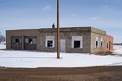
 Vacant store | |
| Coordinates: 49°28′48″N 111°16′34″W / 49.48000°N 111.27611°W | |
| Country | Canada |
| Province | Alberta |
| Region | Southern Alberta |
| Planning region | South Saskatchewan |
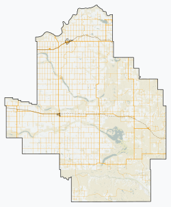
| Municipal district | Forty Mile |
| Founded | 1915 |
| Government | |
| • MP | Glen Motz |
| • MLA | Grant Hunter |
| Time zone | UTC−7 (MST) |
| • Summer (DST) | UTC−6 (MDT) |
| Postal code span | |
| Area code | +1-403 |
| Highways | Highway 61 |
Nemiscam, also known as Nemiskam, and originally known as Bingham, is an unincorporated community within the County of Forty Mile No. 8 in southern Alberta, Canada. The community is roughly 10km east of Foremost, west of Etzikom, Alberta on Highway 61 and is administered by the County of Forty Mile No. 8.[1]
The community is known as a ghost town by people in the area due to being near-vacant with a number of abandoned buildings inside the former town. In light of this fact, the community has become a minor tourism destination from locals in the nearby cities of Calgary, Medicine Hat and other nearby rural communities. The most prominent features of the ghost town are the sign that says "Future home of Kmart", and the abandoned Nemiskam Garage building, both located in the southern half of the ghost town along Township Road 63A.
The ghost town is 10km east of town Foremost and 11km west of the partially abandoned town of Etzikom. The town is located nearby to also ghost towns, such as Altorado which is located 11km south, Conquerville which is about 19km north, and Orion which is 33km east.

History[edit]
Originally, Nemiskam was established as a small community called "Bingham", located 1km southwest of the current townsite. Due to a railway bypass, the citizens of Bingham decided to settle in Nemiskam, with some even bringing their homes and businesses with them. During the community's most prosperous years, a community hall, four grain elevators, a school, and a service station were present in the townsite.
About 11km south of Nemiskam was the old community of Altorado, which by 1913 had a population of over 100. With no prospects of a long-term future in Altorado, as the Canadian Pacific Rail service extended a trainline north of Altorado to the community of Bingham (nowadays Nemiskam), more and more residents of Altorado relocated to Nemiskam. This eventually caused Altorado to become a ghost town similar to what Nemiskam is today.
Beginning in the 1960s, Nemiskam's population totalled 54. By 1966, the population had reduced to just 17. Today, many of the original buildings and residents have once again picked up and moved to find better way of life, most moving to Foremost with some residents even bringing their homes with them. In the early 1990s, the dying community would suffer another loss – its four grain elevators – leaving the community in a ghost town[2] state with only 6 buildings left.
Name origin[edit]
For many years Nemiskam or Nemiscam has had several disputes over the different ways of spelling the community's name. People and map companies of today spell the name with a “C” but many older folk like to spell it with a “K” as it was originally spelled on the towns long gone grain elevators, and community hall, Nemiskam with a “K” is native for “between two valleys”.
Media Coverage[edit]
CBC News on September 10, 2020 released a mini-documentary by the title of 'This Alberta ghost town has no services, but still has guests' covering the ghost town of Nemiskam. This mini-documentary would go into detail about how people have come far and wide to take photos and videos of the abandoned town, and how the old school house is "the most photographed abandoned building in Alberta".[3]
See also[edit]
References[edit]
- ^ County of Forty Mile http://www.municipalaffairs.gov.ab.ca/cfml/profiles/data/0118_1.htm
- ^ Ghost Towns of Alberta by Johnnie Bachusky (Nemiskam) https://www.ghosttownpix.com/alberta/nemiskam.html
- ^ This Alberta ghost town has no services, but still has guests, retrieved April 7, 2023


