
Ålfoten
Ålfoten | |
|---|---|
Village | |
 Ålfoten Location of the village  Ålfoten Ålfoten (Norway) | |
| Coordinates: 61°50′21″N 5°40′34″E / 61.8393°N 5.6762°E | |
| Country | Norway |
| Region | Western Norway |
| County | Vestland |
| District | Nordfjord |
| Municipality | Bremanger Municipality |
| Time zone | UTC+01:00 (CET) |
| • Summer (DST) | UTC+02:00 (CEST) |
| Post Code | 6737 |
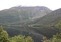
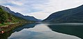
Ålfoten is a village in Bremanger Municipality in Vestland county, Norway. The village is located along the Ålfotfjorden, a branch of the main Nordfjorden and has a population of about 200.
The village has an elementary school, a grocery store and the Ålfoten Church (built in 1678). Ålfoten has two hydroelectric power stations, Åskåra and Yksneelvane.
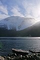
Ålfoten is surrounded by mountains. To the south: Høgefjellet, Bukkenibba and Blånibba. To the north: Nakken, Kårnyken, Kvasshornet and Klakegga.
The Ålfotbreen glacier lies about 10 kilometres (6.2 mi) to the southwest of the village.
Gallery[edit]
-
 Ålfoten
 -
 Ålfoten church
 -
 Mountain Høgefjellet
 -
 Mountain Høgefjellet
 -
 Mountain Nakken
 -
 Mountain Kårnykjen
 -
 Føre
Føre -
 Føre
Føre -
 Føre
Føre


This Vestland location article is a stub. You can help Wikipedia by expanding it. |