
Úštěk
Úštěk | |
|---|---|
 Mírové Square | |
 Flag  Coat of arms | |
 Úštěk Location in the Czech Republic | |
| Coordinates: 50°35′36″N 14°20′55″E / 50.59333°N 14.34861°E | |
| Country | |
| Region | Ústí nad Labem |
| District | Litoměřice |
| First mentioned | 1218 |
| Government | |
| • Mayor | Ondřej Elísek |
| Area | |
| • Total | 74.94 km2 (28.93 sq mi) |
| Elevation | 242 m (794 ft) |
| Population (2023-01-01)[1] | |
| • Total | 2,883 |
| • Density | 38/km2 (100/sq mi) |
| Time zone | UTC+1 (CET) |
| • Summer (DST) | UTC+2 (CEST) |
| Postal codes | 411 08, 411 45 |
| Website | www |
Úštěk (Czech pronunciation: [ˈuːʃcɛk]; German: Auscha) is a town in Litoměřice District in the Ústí nad Labem Region of the Czech Republic. It has about 2,900 inhabitants. The historic town centre is well preserved and is protected by law as an urban monument reservation.
Administrative parts[edit]
Úštek is made up of 3 town parts and 21 villages:
- Úštěk-České Předměstí
- Úštěk-Českolipské Předměstí
- Úštěk-Vnitřní Město
- Bílý Kostelec
- Brusov
- Dolní Vysoké
- Držovice
- Dubičná
- Habřina
- Julčín
- Kalovice
- Konojedy
- Lhota
- Ličenice
- Lukov
- Ostré
- Rašovice
- Robeč
- Rochov
- Starý Týn
- Tetčiněves
- Třebín
- Vědlice
- Zelený
Geography[edit]
Úštěk is located about 15 kilometres (9 mi) northeast of Litoměřice and 22 km (14 mi) southeast of Ústí nad Labem. It lies mostly in the Ralsko Uplands, but the municipal territory also extends to the Central Bohemian Uplands on the north, where is located the highest point of Úštěk, the hill Pohorský vrch at 601 metres (1,972 ft). The town is situated on the Úštěcký Stream and on the shore of the Chmelař Pond.
History[edit]
According to archaeological excavations, the area of Úštěk was inhabited from the 10th century. The importance of Úštěk has increased in the 14th century. Around 1361, the settlement was promoted to a town. In 1475, the town was acquired by marriage by the noble family of Sezima of Ústí. Under their rule, Úštěk prospered and grew rapidly, which lasted until the Battle of White Mountain in 1620. In 1622, the Úštěk property was confiscated and fell to Prague and Litoměřice Jesuits.[2]
Demographics[edit]
|
|
| ||||||||||||||||||||||||||||||||||||||||||||||||||||||
| Source: Censuses[3][4] | ||||||||||||||||||||||||||||||||||||||||||||||||||||||||
Sights[edit]
The town is renowned for its medieval centre, formed by Mírové Square and its surroundings. On the square, houses with Gothic gables have been preserved. The Church of Saints Peter and Paul on the square was built in the late Baroque style in 1764–1772.[5]
The historic centre is delimited by remains of town walls. The Pikart Tower is the largest and strongest tower of the town fortification. It is a sandstone tower built in 1428.[5]
The restored Úštěk Synagogue also is a significant monument.[5]
Gallery[edit]
-
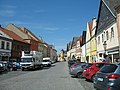 Mírové Square, western part with old houses
 -
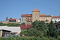 Town fortifications with the Pikart Tower
 -
 Western gate
 -
 Church of Saints Peter and Paul
 -
 Parsonage on Mírové Square
 -
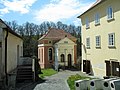 Synagogue and Rabbi's house
.jpg)

.jpg)


.jpg)
References[edit]
- ^ "Population of Municipalities – 1 January 2023". Czech Statistical Office. 2023-05-23.
- ^ "Facts of history". Město Úštěk. Retrieved 2021-07-19.
- ^ "Historický lexikon obcí České republiky 1869–2011 – Okres Litoměřice" (in Czech). Czech Statistical Office. 2015-12-21. pp. 17–18.
- ^ "Population Census 2021: Population by sex". Public Database. Czech Statistical Office. 2021-03-27.
- ^ a b c "Sightseeing tour across Úštěk". Město Úštěk. Retrieved 2021-07-19.
External links[edit]
| International | |
|---|---|
| National | |