
Aalden
Aalden | |
|---|---|
Village | |
 Jantina Hellingmolen windmill | |
 Aalden Location in the province of Drenthe in the Netherlands  Aalden Aalden (Netherlands)  Aalden Aalden (Europe) | |
| Coordinates: 52°46′N 6°43′E / 52.767°N 6.717°E | |
| Country | Netherlands |
| Province | Drenthe |
| Municipality | Coevorden |
| Area | |
| • Total | 1.08 km2 (0.42 sq mi) |
| Elevation | 17 m (56 ft) |
| Population (2021)[1] | |
| • Total | 1,635 |
| • Density | 1,500/km2 (3,900/sq mi) |
| Time zone | UTC+1 (CET) |
| • Summer (DST) | UTC+2 (CEST) |
| Postal code | 7854[1] |
| Dialing code | 0591 |
Aalden is a village in the Netherlands and it is part of the Coevorden municipality in Drenthe.
History[edit]
Aalden developed in the Middle Ages on higher sand ground. The oldest part developed around a triangular village green without a church.[3] It was first mentioned in 1332 as Alede. The etymology is unclear.[4] Nowadays, it forms a single urban area with Zweeloo.[3] In 1840, it was home to 116 people.[5]
The Jantina Hellingmolen is a gristmill from 1891 and is still in service on a voluntary basis.[6]
Gallery[edit]
-
 Protestant church
 -
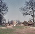 Farms in Aalden
 -
 House in Aalden
 -
 Horses in the mist


.jpg)
References[edit]
- ^ a b c "Kerncijfers wijken en buurten 2021". Central Bureau of Statistics. Retrieved 12 March 2022.
- ^ "Postcodetool for 7854NA". Actueel Hoogtebestand Nederland (in Dutch). Het Waterschapshuis. Retrieved 12 March 2022.
- ^ a b Ronald Stenvert (2001). Aalden (in Dutch). Zwolle: Waanders. p. 61. ISBN 90 400 9454 3. Retrieved 12 March 2022.
- ^ "Aalden - (geografische naam)". Etymologiebank (in Dutch). Retrieved 12 March 2022.
- ^ "Aalden". Plaatsengids (in Dutch). Retrieved 12 March 2022.
- ^ "Jantina Hellingmolen". Molendatabase (in Dutch). Retrieved 12 March 2022.
Wikimedia Commons has media related to Aalden.
This Drenthe location article is a stub. You can help Wikipedia by expanding it. |