
Andes
Template:Otherusesabout Template:Geobox
The Andes form the world's longest exposed mountain range.[1] They lie as a continuous chain of highland along the western coast of South America. The range is over 7,000 km (4,400 miles) long, 500 km (300 miles) wide in some parts (widest between 18° to 20°S latitude), and of an average height of about 4,000 m (13,000 ft).
The Andean range is composed principally of two great ranges, the Cordillera Oriental and the Cordillera Occidental, often separated by a deep intermediate depression, in which arise other chains of minor importance, the chief of which is Chile's Cordillera de la Costa. Other small chains arise on the sides of the great chains. The Cordillera de la Costa starts from the southern extremity of the continent and runs in a northerly direction, parallel with the coast, being broken up at its beginning into a number of islands and afterwards forming the western boundary of the great central valley of Chile. To the north this coastal chain continues in small ridges or isolated hills along the Pacific Ocean as far as Venezuela, always leaving the same valley more or less visible to the west of the Western Great Chain. The mountains extend over seven countries: Argentina, Bolivia, Chile, Colombia, Ecuador, Peru and Venezuela, some of which are known as Andean States.
The Andes mountain range is the highest mountain range outside Asia. The highest peak, Aconcagua, rises to 6,962 m (22,841 ft) above sea level. The summit of Mount Chimborazo in the Ecuadorean Andes is the point on the Earth's surface most distant from its center, because of the equatorial bulge.
Name
There are many theories about the etymology of the name Andes. Some believe Andes derives from the Quechua word anti, which means "high crest". Some believe Andes derives from one of the four regions of the Inca empire, or Anti(s). Some believe Andes derives from the Spanish word andén which means terrace in reference to the cultivation terraces used by the Incas and other related peoples. Some believe Andes is Old Spanish shorthand for "Andenes" or "Andenerías"[citation needed].
Physical features
The Andes can be divided into three sections: the Southern Andes in Argentina and Chile; the Central Andes, including the Chilean and Peruvian cordilleras and parts of Bolivia; and the northern section in Venezuela, Colombia, and northern Ecuador consisting of two parallel ranges, the Cordillera Occidental and the Cordillera Oriental. In Colombia, north to the border with Ecuador, the Andes split in three parallel ranges, western, central and eastern. (cordillera occidental, central y oriental). The eastern range is the only one that extends to Venezuela. The term cordillera comes from the Spanish word meaning 'rope'. The Andes range is approximately 200–300 km (125–190 mi) wide throughout its length, except in the Bolivian flexure where it is 640 km (398 mi) wide. The islands of Aruba,Bonaire, and Curaçao, which lie in the Caribbean Sea off the coast of Venezuela, represent the submerged peaks of the extreme northern edge of the Andes range.
Geology

The Andes fundamentally are the result of plate tectonics processes, caused by the subduction of the Nazca plate beneath the South American plate. The boundary between the two plates is marked by the Peru-Chile oceanic trench.
The formation of the Andes began in the Jurassic Period. It was during the Cretaceous Period that the Andes began to take their present form, by the uplifting, faulting and folding of sedimentary and metamorphic rocks of the ancient cratons to the east. Tectonic forces along the subduction zone along the entire west coast of South America where the Nazca Plate and a part of the Antarctic Plate are sliding beneath the South American Plate continue to produce an ongoing orogenic event resulting in minor to major earthquakes and volcanic eruptions to this day. In the extreme south a major transform fault separates Tierra del Fuego from the small Scotia Plate. Across the 1,000 km (620 mi) wide Drake Passage lie the mountains of the Antarctic Peninsula south of the Scotia Plate which appear to be a continuation of the Andes chain.
The Andes range has many active volcanoes, including Cotopaxi, one of the highest active volcanoes in the world.
Climate
The climate in the Andes varies greatly depending on location, altitude, and proximity to the sea. The southern section is rainy and cool, the central Andes are dry. The northern Andes are typically rainy and warm, with an average temperature of 18 °C (64 °F) in Colombia. The climate is known to change drastically. Rainforests exist just miles away from the snow covered peak, Cotopaxi. The mountains have a large effect on the temperatures of nearby areas. The snow line depends on the location. It is at between 4,500–4,800 m (14,800–15,800 ft) in the tropical Ecuadorian, Colombian, Venezuelan, and northern Peruvian Andes, rising to 4,800–5,200 m (15,800–17,060 ft) in the drier mountains of southern Peru south to northern Chile south to about 30°S, then descending to 4,500 m (14,760 ft) on Aconcagua at 32°S, 2,000 m (6,600 ft) at 40°S, 500 m (1,640 ft) at 50°S, and only 300 m (980 ft) in Tierra del Fuego at 55°S; from 50°S, several of the larger glaciers descend to sea level.[2]
Fauna and flora

The Andes is rich in fauna and flora. About 30,000 species of vascular plants live in the Andes with roughly half being endemic to the region, surpassing the diversity of any other hotspot.[3] With almost 1000 species, of which roughly 2/3 are endemic to the region, the Andes is the most important region in the world for amphibians.[3] For other major groups the numbers are equally impressive: Almost 600 species of mammals (13% endemic), more than 1,700 species of birds (c. 1/3 endemic), more than 600 species of reptiles (c. 45% endemic), and almost 400 species of fishes (c. 1/3 endemic).[3]
Tropical rainforests and rainforests used to encircle the northern Andes but are now greatly diminished, especially in the Chocó and inter-Andean valleys of Colombia. The small tree Cinchona pubescens, a source of quinine which is used to treat malaria, is found widely in the Andes as far south as Bolivia. Other important crops that originated from the Andes are tobacco and potatoes. The high-altitude Polylepis forests and woodlands are found in the Andean areas of Colombia, Ecuador, Peru, Bolivia and Chile. These trees, by locals referred to as Queñua, Yagual and other names, can be found at altitudes of 4,500 m (14,760 ft) above sea level. It remains unclear if the patchy distribution is natural, or the result of clearance which started during the Incan period. Regardless, in modern times the clearance has accelerated, and the trees are now considered to be highly endangered, with some believing that as little as 10% of the original woodland remains.[4] A number of species such as the Royal Cinclodes and White-browed Tit-spinetail are associated with Polylepis, and consequently also threatened.
The Vicuña and Guanaco can be found living in the Altiplano, while the closely related domesticated Llama and Alpaca are widely kept by locals as pack animals and for their meat and wool. The nocturnal chinchillas, two threatened members of the rodent order, inhabits the Andes' alpine regions. The Andean Condor, the largest bird of its kind in the Western Hemisphere, occurs throughout a large part of the Andes, but generally in very low densities. Other animals found in the relatively open habitats of the high Andes include the huemul, cougar, foxes in the genus Pseudalopex, and, for birds, certain species of Tinamous (notably members of the genus Nothoprocta), Andean Goose, Giant Coot, flamingos (mainly associated with hypersaline lakes), Lesser Rhea, Andean Flicker, Diademed Sandpiper-Plover, miners, sierra-finches and Diuca-finches. The massive Lake Titicaca hosts several endemics, among them the highly endangered Titicaca Flightless Grebe and Titicaca Water Frog. A few species of hummingbirds, notably some hillstars, can be seen at altitudes above 4,000 m (13,100 ft), but far higher diversities can be found at lower altitudes, especially in the humid Andean forests ("cloud forests") growing on slopes in Colombia, Ecuador, Peru, Bolivia and far north-western Argentina. These forest-types, which includes the Yungas and parts of the Chocó, are very rich in flora and fauna, although few large mammals exists, exceptions being the threatened Mountain Tapir, Spectacled Bear and Yellow-tailed Woolly Monkey. Birds of humid Andean forests include Mountain-Toucans, Quetzals and the Andean Cock-of-the-rock, while mixed species flocks dominated by tanagers and Furnariids commonly are seen - in contrast to several vocal, but typically cryptic, species of wrens, tapaculos and antpittas. As a direct opposite of the humid Andean slopes are the relatively dry Andean slopes in most of western Peru, Chile and Argentina. Along with several Interandean Valles, they are typically dominated by deciduous woodland, shrub and/or xeric vegetation, reaching the extreme in the slopes near the virtually lifeless Atacama Desert.
People

The Inca Empire developed in the northern Andes during the 1400s. The Incas formed this civilization through imperialistic militarism as well as careful and meticulous governmental management. The government sponsored the construction of aqueducts and roads, some of which, like those created by the Romans, are still in existence today. The aqueducts turned the previously scattered Incan tribe into the agricultural and eventually militaristic masters of the region.[citation needed]
Devastated by deadly European diseases to which they had no immunity, and by a terrible civil war, in 1532 the Incas were defeated by an alliance composed by tens of thousands allies from nations they had subjugated (huancas, chachapoyas, cañaris, etc) and a small army of 180 Spaniards led by Pizarro. One of the few Inca cities the Spanish never found in their conquest was Machu Picchu, which lay hidden on a peak on the edge of the Andes where they descend to the Amazon. The main surviving languages of the Andean peoples are those of the Quechua and Aymara language families.
Mountaineering/surveying
Woodbine Parish and Joseph Barclay Pentland surveyed a large part of the Bolivian Andes from 1826 to 1827.
Transportation
Several major cities exist in the Andes, among them the capital of Colombia, Bogotá, the capital of Ecuador, Quito, the capital of Bolivia, La Paz, and the famous Peruvian city of Cusco. These and most other cities are now connected with asphalted roads, while smaller town often are connected by dirt roads, which may require a 4x4 vehicle. Due to the arduous terrain, localities where vehicles are of little use remain. Locally, Llamas continue to play an important role as pack animals, but this use has generally diminished in modern times.
Agriculture
The ancient peoples of the Andes such as the Incas have practiced irrigation techniques for over 6,000 years. Because of the mountain slopes, terracing has been a common practice. Terracing, however, was only extensively employed after Incan imperial expansions to fuel their expanding realm. The potato holds a very important role as an internally consumed staple crop. Maize was also an important crop for these people. However, they were mainly used for the production of the culturally important chicha. Currently, tobacco, cotton and coffee are the main export crops. Coca, despite eradication programmes in some countries, remains an important crop for legal local use in a mildly stimulating herbal tea, and, both controversially and illegally, for the production of cocaine.

Mining
Mining is quite prosperous in the Andes, with iron, gold, silver, tin and copper being the main production minerals.
Peaks
This list contains some of the major peaks in the Andes mountain range.
Argentina
- See also List of mountains in Argentina
- Aconcagua, 6,962 m (22,841 ft)
- Cerro Bonete, 6,759 m (22,175 ft) (not 6,872 m)
- Galán, 5,912 m (19,396 ft) (not 6,600 m)
- Mercedario, 6,720 m (22,047 ft)
- Pissis, 6,795 m (22,293 ft) (not 6,882 m)
-
Aconcagua, Argentina
-
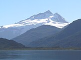 Cerro Tronador, Argentina

Border between Argentina and Chile
- Cerro Bayo, 5,401 m (17,720 ft)
- Cerro Chaltén, 3,375 m (11,073 ft) or 3,405 m, Patagonia, also known as Cerro Fitz Roy
- Cerro Escorial, 5,447 m (17,871 ft)
- Cordón del Azufre, 5,463 m (17,923 ft)
- Falso Azufre, 5,890 m (19,324 ft)
- Incahuasi, 6,620 m (21,719 ft)
- Lastarria, 5,697 m (18,691 ft)
- Llullaillaco, 6,739 m (22,110 ft)
- Maipo, 5,264 m (17,270 ft)
- Marmolejo, 6,110 m (20,046 ft)
- Ojos del Salado, 6,893 m (22,615 ft)
- Olca, 5,407 m (17,740 ft)
- Sierra Nevada de Lagunas Bravas, 6,127 m (20,102 ft)
- Socompa, 6,051 m (19,852 ft)
- Nevado Tres Cruces, 6,749 m (south summit) (III Region)
- Tronador, 3,491 m (11,453 ft)
- Tupungato, 6,570 m (21,555 ft)
- Nacimiento, 6,492 m (21,299 ft)
-
-
 Llullaillaco, Chile/Argentina


Bolivia
- Ancohuma, 6,427 m (21,086 ft)
- Cabaray, 5,860 m (19,226 ft)
- Chacaltaya, 5,421 m (17,785 ft)
- Huayna Potosí, 6,088 m (19,974 ft)
- Illampu, 6,368 m (20,892 ft)
- Illimani, 6,438 m (21,122 ft)
- Macizo de Larancagua, 5,520 m (18,110 ft)
- Macizo de Pacuni, 5,400 m (17,720 ft)
- Nevado Anallajsi, 5,750 m (18,865 ft)
- Nevado Sajama, 6,542 m (21,463 ft)
- Patilla Pata, 5,300 m (17,390 ft)
- Tata Sabaya, 5,430 m (17,815 ft)
Border between Bolivia and Chile
- Acotango, 6,052 m (19,856 ft)
- Cerro Minchincha, 5,305 m (17,405 ft)
- Irruputuncu, 5,163 m (16,939 ft)
- Licancabur, 5,920 m (19,423 ft) (there is no "6,620 m Lincancaur" in Argentina)
- Olca, 5,407 m (17,740 ft)
- Parinacota, 6,348 m (20,827 ft)
- Paruma, 5,420 m (17,782 ft)
- Pomerape, 6,282 m (20,610 ft)
-
 Licancabur, Bolivia/Chile
 -
 Parinacota


Chile
- See also List of mountains in Chile
- Monte San Valentin, 4,058 m (13,314 ft) (Patagonia)
- Cerro Paine Grande, c.2,750 m (9,022 ft) (Patagonia) (not 3,050 m)
- Cerro Macá, c.2,300 m (7,546 ft) (Patagonia) (not 3,050 m)
- Monte Darwin, c.2,500 m (8,202 ft) (Patagonia)
- Volcan Hudson, c.1,900 m (6,234 ft) (Patagonia)
- Cerro Castillo Dynevor, c.1,100 m (3,609 ft) (Patagonia)
- Mount Tarn, c.825 m (2,707 ft) (Patagonia)
-
 Santiago de Chile on the western slopes of a snowcapped Andes
 -
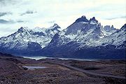
 View of Cuernos del Paine in Torres del Paine National Park


Colombia
- Galeras, 4,276 m (14,029 ft)
- Nevado del Huila, 5,365 m (17,602 ft)
- Nevado del Ruiz, 5,321 m (17,457 ft)
- Ritacuba Blanco, 5,410 m (17,749 ft)
- Snow Mountain of Quindio, 5,215 m (17,110 ft)
Ecuador
- Antisana, 5,753 m (18,875 ft)
- Cayambe, 5,790 m (18,996 ft)
- Chimborazo, 6,268 m (20,564 ft)
- Corazón, 4,790 m (15,715 ft)
- Cotopaxi, 5,897 m (19,347 ft)
- El Altar, 5,320 m (17,454 ft)
- Illiniza, 5,248 m (17,218 ft)
- Pichincha, 4,784 m (15,696 ft)
- Quilotoa, 3,914 m (12,841 ft)
- Reventador, 3,562 m (11,686 ft)
- Sangay, 5,230 m (17,159 ft)
- Tungurahua, 5,023 m (16,480 ft)
-
-
 Chimborazo, Ecuador

Peru
- Alpamayo, 5,947 m (19,511 ft)
- Artesonraju, 6,025 m (19,767 ft)
- Carnicero, 5,960 m (19,554 ft)
- El Misti, 5,822 m (19,101 ft)
- El Toro, 5,830 m (19,127 ft)
- Huascarán, 6,768 m (22,205 ft)
- Jirishanca, 6,094 m (19,993 ft)
- Pumasillo, 5,991 m (19,656 ft)
- Rasac, 6,040 m (19,816 ft)
- Rondoy, 5,870 m (19,259 ft)
- Sarapo, 6,127 m (20,102 ft)
- Seria Norte, 5,860 m (19,226 ft)
- Siula Grande, 6,344 m (20,814 ft)
- Yerupaja, 6,635 m (21,768 ft)
- Yerupaja Chico, 6,089 m (19,977 ft)


Venezuela
- Pico Bolívar, 4,981 m (16,342 ft)
- Pico Humboldt, 4,940 m (16,207 ft)
- Pico La Concha, 4,870 m (15,978 ft)
- Pico Piedras Blancas, 4,740 m (15,551 ft)
-
 Pico Bolívar, Venezuela
 -
Pico Humboldt, Venezuela

References
- ^ Explanation: The world's longest mountain range of any type is the undersea Ocean ridge, with a total length of 80,000 km (49,700 mi).
- ^ "Climate of the Andes". Retrieved 2007-12-09.
{{cite web}}: Cite has empty unknown parameter:|coauthors=(help) - ^ a b c Tropical Andes - biodiversityhotspots.org
- ^ "Plants of the Andes". Retrieved 2007-12-09.
{{cite web}}: Cite has empty unknown parameter:|coauthors=(help)
- John Biggar, The Andes: A Guide For Climbers, 3rd. edition, 2005, ISBN 0-9536087-2-7
- Tui de Roy, The Andes: As the Condor Flies. 2005, ISBN 1-55407-070-8
- Fjeldså, J., & N. Krabbe (1990). The Birds of the High Andes. Zoological Museum, University of Copenhagen, Copenhagen. ISBN 87-88757-16-1
- Fjeldså, J. & M. Kessler. 1996. Conserving the biological diversity of Polylepis woodlands of the highlands on Peru and Bolivia, a contribution to sustainable natural resource management in the Andes. NORDECO, Copenhagen.
External links
- Andes geology (University of Arizona)
- Climate and animal life of the Andes
- http://www.peaklist.org/WWlists/ultras/southamerica.html Complete list of mountains in South America with a prominence of at least 1,500 m (4,920 ft)