
Arminto, Wyoming
Arminto, Wyoming | |
|---|---|
 South view of Arminto, Wyoming | |
 Arminto, Wyoming Location within the state of Wyoming  Arminto, Wyoming Arminto, Wyoming (the United States) | |
| Coordinates: 43°10′44″N 107°15′27″W / 43.17889°N 107.25750°W | |
| Country | United States |
| State | Wyoming |
| County | Natrona |
| Elevation | 6,053 ft (1,845 m) |
| Population (2000) | |
| • Total | 5 |
| Time zone | UTC-7 (Mountain (MST)) |
| • Summer (DST) | UTC-6 (MDT) |
| ZIP code | 82630[1] |
| Area code | 307 |
| GNIS feature ID | 1584934[2] |
Arminto is an unincorporated community in northwestern Natrona County, Wyoming, United States. It lies along local roads west of the city of Casper, the county seat of Natrona County.[3] Its elevation is 6,053 feet (1,845 m).[2]
History[edit]
Arminto was built as a stop on the Chicago, Burlington and Quincy Railroad, and was named for Manuel Armenta who started the nearby Jack Pot Ranch.[4] Arminto voted to incorporate in 1915; unincorporated towns could not sell liquor in Wyoming at the time.[5]
Although Arminto is now unincorporated, it had a post office, that closed in 1964.[6]
The Big Horn Hotel was moved from Wolton to Arminto in 1913 when the railroad arrived there. It was entered on the National Register of Historic Places in 1978, and was destroyed by a fire in 1985.[7]
Climate[edit]
According to the Köppen Climate Classification system, Arminto has a semi-arid climate, abbreviated "BSk" on climate maps.[8]
References[edit]
- ^ "Arminto ZIP Code". zipdatamaps.com. 2022. Retrieved November 11, 2022.
- ^ a b "Arminto, Wyoming". Geographic Names Information System. United States Geological Survey, United States Department of the Interior.
- ^ Rand McNally. The Road Atlas '08. Chicago: Rand McNally, 2008, p. 116.
- ^ Wyoming Place Names, p. 160, Annals of Wyoming (1942)
- ^ (9 March 1915). Incorporate to Get Saloons, Cheyenne State Leader
- ^ "Postmaster Finder - Who We Are - USPS". about.usps.com. Retrieved December 13, 2019.
- ^ Nomination Form (1978)
- ^ "Arminto, Wyoming Köppen Climate Classification (Weatherbase)". Weatherbase. Retrieved December 13, 2019.
Municipalities and communities of Natrona County, Wyoming, United States | ||
|---|---|---|
| City | 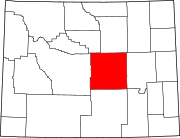 | |
| Towns | ||
| CDPs | ||
| Unincorporated communities | ||
This article about a location in Wyoming is a stub. You can help Wikipedia by expanding it. |