Ashland, Montana: Difference between revisions
No edit summary |
|||
| Line 85: | Line 85: | ||
Ashland is located at {{coord|45|36|27|N|106|17|11|W|type:city}} (45.607457, -106.286284){{GR|1}}. |
Ashland is located at {{coord|45|36|27|N|106|17|11|W|type:city}} (45.607457, -106.286284){{GR|1}}. |
||
According to the [[United States Census Bureau]], the CDP has a total area of {{convert|7.6|sqmi|km2}}, all of it land. |
According to the [[United States Census Bureau]], the CDP has a total area of {{convert|7.6|sqmi|km2}}, all of it land. okay my friends shurlece sausity and jenni all live there and there all like super cool and fun to hang out with .but kida a crow so yeah we cant make fun of the crow i meet all of them on the montana ride it was so hot but not jenni i meet her just this year when we had break oh and shurlies always has these cool oh glasses that are awsome aye. |
||
'''ALEXIS WILLIAMS''' |
|||
==Demographics== |
==Demographics== |
||
Revision as of 19:14, 24 September 2012
Ashland, Montana
Vóhkoohémâhoéve'ho'éno | |
|---|---|
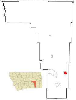
 Location of Ashland, Montana | |
| Country | United States |
| State | Montana |
| County | Rosebud |
| Area | |
| • Total | 7.6 sq mi (19.6 km2) |
| • Land | 7.6 sq mi (19.6 km2) |
| • Water | 0.0 sq mi (0.0 km2) |
| Elevation | 2,920 ft (890 m) |
| Population (2000) | |
| • Total | 464 |
| • Density | 61.4/sq mi (23.7/km2) |
| Time zone | UTC-7 (Mountain (MST)) |
| • Summer (DST) | UTC-6 (MDT) |
| ZIP codes | 59003-59004 |
| Area code | 406 |
| FIPS code | 30-02800 |
| GNIS feature ID | 0802003 |
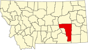
Ashland is a census-designated place (CDP) in Rosebud County, Montana, United States. The population was 464 at the 2000 census. Ashland is immediately east of the boundary of the Northern Cheyenne Indian Reservation and the location of the St. Labre Indian Catholic High School, established in 1884 as a boarding school by a Catholic mission to the Cheyenne.[1]
Geography
Ashland is located at 45°36′27″N 106°17′11″W / 45.60750°N 106.28639°W (45.607457, -106.286284)Template:GR.
According to the United States Census Bureau, the CDP has a total area of 7.6 square miles (20 km2), all of it land. okay my friends shurlece sausity and jenni all live there and there all like super cool and fun to hang out with .but kida a crow so yeah we cant make fun of the crow i meet all of them on the montana ride it was so hot but not jenni i meet her just this year when we had break oh and shurlies always has these cool oh glasses that are awsome aye. ALEXIS WILLIAMS
Demographics
As of the censusTemplate:GR of 2000, there were 464 people, 151 households, and 104 families residing in the CDP. The population density was 61.4 people per square mile (23.7/km²). There were 170 housing units at an average density of 22.5 per square mile (8.7/km²). The racial makeup of the CDP was 21.55% White, 75.22% Northern Cheyenne, 0.22% Asian, and 3.02% from two or more races. Hispanic or Latino of any race were 1.94% of the population.
There were 151 households out of which 49.0% had children under the age of 18 living with them, 37.7% were married couples living together, 21.9% had a female householder with no husband present, and 30.5% were non-families. 25.8% of all households were made up of individuals and 2.6% had someone living alone who was 65 years of age or older. The average household size was 3.07 and the average family size was 3.60.
In the CDP the population was spread out with 40.9% under the age of 18, 10.8% from 18 to 24, 30.0% from 25 to 44, 15.5% from 45 to 64, and 2.8% who were 65 years of age or older. The median age was 24 years. For every 100 females there were 93.3 males. For every 100 females age 18 and over, there were 87.7 males.
The median income for a household in the CDP was $22,222, and the median income for a family was $24,167. Males had a median income of $24,688 versus $19,000 for females. The per capita income for the CDP was $9,577. About 30.4% of families and 34.7% of the population were below the poverty line, including 41.1% of those under age 18 and none of those age 65 or over.
Education
St. Labre Indian Catholic School, Home of the Braves and Lady Braves. Grades are Pre-K Through 12. The school has been established for almost 129 years now. St. Labre is a 4-C District including Carter County, Custer, Garfield County, Hysham, Melstone, Northern Cheyenne, Plevna, Rosebud, Terry, and Wibaux. The School is particilrly known for their Boys and Girls Basketball team.
Ashland Public School. Grades include K-8.
References
- ^ Page 90, We, the Northern Cheyenne People: our land, our history, our culture (2008), Ambler, Marjane; Little Bear, Richard E; Wilson, Dave; Tall Bull, Linwood; Hantz, Joan; Ward, Carol; Wertman, Bill; Chief Dull Knife College, Lame Deer, Montana

