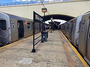
Astoria–Ditmars Boulevard station
Astoria–Ditmars Boulevard | |||||||||
|---|---|---|---|---|---|---|---|---|---|
 | |||||||||
| Station statistics | |||||||||
| Address | 23rd Avenue, Ditmars Boulevard and 31st Street Queens, NY 11105 | ||||||||
| Borough | Queens | ||||||||
| Locale | Astoria | ||||||||
| Division | B (BMT)[1] | ||||||||
| Line | BMT Astoria Line | ||||||||
| Services | N W | ||||||||
| Transit | |||||||||
| Structure | Elevated | ||||||||
| Platforms | 1 island platform | ||||||||
| Tracks | 2 | ||||||||
| Other information | |||||||||
| Opened | February 1, 1917 | ||||||||
| Opposite- direction transfer | N/A | ||||||||
| Traffic | |||||||||
| 2023 | 3,234,661[2] | ||||||||
| Rank | 100 out of 423[2] | ||||||||
| Station succession | |||||||||
| Next north | Template:NYCS next | ||||||||
| Next south | Template:NYCS next | ||||||||
| |||||||||
Astoria–Ditmars Boulevard is the northern terminal station on the BMT Astoria Line of the New York City Subway. Located above 31st Street between 23rd Avenue and Ditmars Boulevard in Astoria, Queens, it is served by the N train at all times, as well as by the Q train on weekdays.
History

This elevated station opened on February 1, 1917,[4] along with the opening of the rest of the Astoria Line, as an IRT line station, and the BRT (later BMT) also provided joint service. Dignitaries from the first ride included President of Alderman Frank Dowling, Public Service Commissioner Hodges, numerous other officials of the commission, President Shonts of the IRT, with a number of his assistants, and Queens Borough President Connolly. Members of the PSC pointed out the need of extending the line from the terminal to Ditmars Boulevard and Steinway Street.[4] Regular passenger service started that afternoon.[4] The station's name was originally Second Avenue, which was the name of Ditmars Boulevard at the station's opening.[5][4]
In 1949, the joint service was discontinued, leaving the BMT to provide full-time service.[6]
In 1981, the MTA listed the station among the 69 most deteriorated stations in the subway system.[7]
Station layout
| Platform level | Southbound | ← ← |
| Island platform | ||
| Southbound | ← ← | |
| Mezzanine | Fare control, station agent, MetroCard and OMNY machines | |
| Ground | Street level | Exit/entrance |
| style="color:;background:#Template:NYCS color;text-align:center;padding:5px"| Track layout | ||||||||||||||||||||||||||||||||||||||||||||||||||||||||||||||||||||||||||||||||||||
|---|---|---|---|---|---|---|---|---|---|---|---|---|---|---|---|---|---|---|---|---|---|---|---|---|---|---|---|---|---|---|---|---|---|---|---|---|---|---|---|---|---|---|---|---|---|---|---|---|---|---|---|---|---|---|---|---|---|---|---|---|---|---|---|---|---|---|---|---|---|---|---|---|---|---|---|---|---|---|---|---|---|---|---|---|
| ||||||||||||||||||||||||||||||||||||||||||||||||||||||||||||||||||||||||||||||||||||
This station has two tracks and an island platform and is partially located under the New York Connecting Railroad (NYCR). The tracks end at bumper blocks at the north end of the platform. The platform canopy extends to the portion of the platform under the NYCR.
The station's only mezzanine is a station house beneath the tracks and platforms. Two double-wide staircases from the platform go down to their own bank of turnstiles with a token booth in the middle. Outside fare control, there are four staircases, two going down to the west side of 31st Street between Ditmars Boulevard and 23rd Avenue and two going down to the east side. The east side of the station house has a short, enclosed pedestrian bridge that leads to the Ditmars Plaza Mini Mall, located on the second floor of the adjacent Garry Building. This mall has a staircase to the street, providing another entrance to the station.
The tracks terminate at bumper blocks at the north end of the station. Past the station's north end, the structure extends for a couple more yards before it ends; this was meant for an extension going east toward LaGuardia Airport. This was part of a never-built extension toward Bayside.[8]
References
- ^ "Glossary". Second Avenue Subway Supplemental Draft Environmental Impact Statement (SDEIS) (PDF). Vol. 1. Metropolitan Transportation Authority. March 4, 2003. pp. 1–2. Archived from the original (PDF) on February 26, 2021. Retrieved January 1, 2021.
- ^ a b "Annual Subway Ridership (2018–2023)". Metropolitan Transportation Authority. 2023. Retrieved April 20, 2024.
- ^ "Facts and Figures: Annual Subway Ridership". Metropolitan Transportation Authority. Retrieved 2016-04-16.
- ^ a b c d "First Train Runs On Elevated Line to Astoria Section". http://bklyn.newspapers.com. Brooklyn Daily Eagle. February 1, 1917. Retrieved 29 June 2015.
- ^ [1]
- ^ "www.nycsubway.org: BMT Astoria Line". www.nycsubway.org. Retrieved 2016-02-21.
- ^ Gargan, Edward A. (June 11, 1981). "AGENCY LISTS ITS 69 MOST DETERIORATED SUBWAY STATIONS". The New York Times. Retrieved 13 August 2016.
- ^ Martin, Douglas (November 17, 1996). "Subway Planners' Lofty Ambitions Are Buried as Dead-End Curiosities". nytimes.com. The New York Times. Retrieved 27 June 2015.
External links
- nycsubway.org – BMT Astoria Line: Ditmars Boulevard
- Station Reporter — N Train
- Ditmars Boulevard entrance from Google Maps Street View
- Platform from Google Maps Street View
