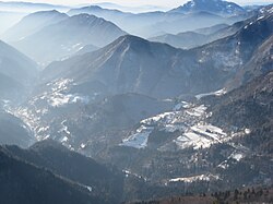
Bača pri Podbrdu
Bača pri Podbrdu | |
|---|---|
 | |
| Coordinates: 46°13′23.16″N 13°58′11.4″E / 46.2231000°N 13.969833°E | |
| Country | |
| Traditional region | Slovenian Littoral |
| Statistical region | Gorizia |
| Municipality | Tolmin |
| Area | |
| • Total | 3.99 km2 (1.54 sq mi) |
| Elevation | 749.6 m (2,459.3 ft) |
| Population (2002) | |
| • Total | 23 |
| [1] | |
Bača pri Podbrdu (pronounced [ˈbaːtʃa pɾi pɔdˈbəɾdu]) is a dispersed settlement above Podbrdo in the Municipality of Tolmin in the Littoral region of Slovenia. It lies on the southern slopes of Mount Kobla and is a popular starting point for hiking trips into the surrounding peaks of the southern Julian Alps.[2]
The local church is dedicated to Saint Leonard and belongs to the Parish of Podbrdo.[3]
Name[edit]
The name of the settlement was changed from Bača to Bača pri Podbrdu (literally, 'Bača near Podbrdo') in 1955,[4] distinguishing it from nearby Bača pri Modreju. The settlement was attested as Binchinvel in 1377. The origin of the name Bača is uncertain; it may be derived from the Slavic root *bač-, referring to a wet or damp place, or, less likely, from a personal name.[5]
References[edit]
- ^ Statistical Office of the Republic of Slovenia
- ^ Tolmin municipal site
- ^ Koper Diocese list of churches Archived March 6, 2009, at the Wayback Machine
- ^ Spremembe naselij 1948–95. 1996. Database. Ljubljana: Geografski inštitut ZRC SAZU, DZS.
- ^ Snoj, Marko (2009). Etimološki slovar slovenskih zemljepisnih imen. Ljubljana: Modrijan. pp. 50–51.
External links[edit]


