
Bavel, Netherlands
Bavel | |
|---|---|
Village | |
_DSCF4847.jpg) Former monastery | |
 Flag  Coat of arms | |
 Bavel Location in the province of North Brabant in the Netherlands  Bavel Bavel (Netherlands) | |
| Coordinates: 51°34′26″N 4°49′51″E / 51.57389°N 4.83083°E | |
| Country | Netherlands |
| Province | North Brabant |
| Municipality | Breda Alphen-Chaam |
| Area | |
| • Total | 12.88 km2 (4.97 sq mi) |
| Elevation | 7 m (23 ft) |
| Population (2021)[1] | |
| • Total | 8.375 |
| • Density | 0.65/km2 (1.7/sq mi) |
| Time zone | UTC+1 (CET) |
| • Summer (DST) | UTC+2 (CEST) |
| Postal code | 4854 & 4895[1] |
| Dialing code | 0161 |
Bavel is a village in the southern Netherlands. It is located in the Dutch province of North Brabant, largely within the municipality of Breda with some rural areas in the municipality of Alphen-Chaam.
Bavel has a population of around 8,300, [3] the majority of the inhabitants live in the village itself, and some 590 in the surrounding countryside, including the hamlets of Roosberg, Eikberg, Bolberg, Tervoort, Lijndonk and Lage Aard.[citation needed]
History[edit]
Bavel is first mentioned in 1299, in a document dealing with the distribution of the revenues in the parish of Gilze, of which Bavel was a part at that time, and the rights of the Abbey in Thorn, the owners of the area, to collect one tenth of the harvest,[4] called "tienden". The streets "Tiendweg" and "Abdij van Thornstraat" in Bavel bear witness to this historical connection.
In 1316 Bavel was separated from the parish of Gilze and gets its own church, devoted to St. Brigida.[5] After the 80-years war in 1648, Catholicism became banned, and the church fell to the Protestants. The catholic population improvised a catholic church in the hamlet of IJpelaar (today part of the city of Breda) until 1743, in which year they build a new church, presumably at the "Kerkeind". In 1809, the French king Lodewijk Napoleon returned the original church back to the catholic population. In this time, a French "telegraphe" was installed on the tower of the church, to convey messages fast from Paris to Amsterdam.
In 1887 a new church building, located roughly opposite the street of the old one, devoted to the Assumption of Mary was taken into use, and is still in use. The location of the old church is now the a graveyard, and the little chapel is constructed from material of the old church.
Until 1942 Bavel was part of the municipality of Ginneken en Bavel. In that year the city of Breda annexed Ginneken and what remained of the old borough became Nieuw-Ginneken. In 1997 the municipality of Nieuw Ginneken ceased to exist after the population centres on the border to Breda were annexed by this city. In the period 2003–2006, a new residential area along the former borderline between the city of Breda and Nieuw-Ginneken was established (Nieuw Wolfslaar). The city had also planned to construct a new village on at Lijndonk/Tervoort, but these plans have recently been cancelled.[6]
Gallery[edit]
-
 Assumption of Mary Church in Bavel, built in 1887
 -
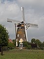 Wind mill De Hoop
 -
 Farm in Bavel
 -
 Pub and party centre


References[edit]
- ^ a b c "Kerncijfers wijken en buurten 2021" (XLS). Central Bureau of Statistics. Retrieved 14 April 2022.
two entries
- ^ "Postcodetool for 4854AA". Actueel Hoogtebestand Nederland (in Dutch). Het Waterschapshuis. Retrieved 14 April 2022.
- ^ "Overzicht wijk Bavel". Alle Cijfers (in Dutch). Archived from the original on 2018-09-27. Retrieved 27 September 2018.
- ^ "Bavel: historie van een 700-jarige gehuchtenzwerm" (in Dutch).
- ^ van der Aa, Abraham (1839). Aardrijkskundig woordenboek der Nederlanden (in Dutch). Vol. 2. p. 194.
- ^ Breda past in hoog tempo bouwplannen aan (in Dutch)
External links[edit]
 Media related to Bavel at Wikimedia Commons
| International | |
|---|---|
| National | |