
Beaver Brook Falls Wayside
| Beaver Brook Falls Wayside | |
|---|---|
 | |
 | |
| Location | 432 Route 145, Colebrook Coos County, New Hampshire |
| Coordinates | 44°55′12″N 71°27′53″W / 44.92004°N 71.46480°W |
| Area | 7.3 acres (3.0 ha) |
| Elevation | 1,122 ft (342 m)[1] |
| Administered by | New Hampshire Division of Parks and Recreation |
| Website | Beaver Brook Falls Wayside |
Beaver Brook Falls Wayside is a 7.3-acre (3.0 ha) park in Colebrook, New Hampshire, along Route 145. It features a roadside view of the scenic 80-foot (24 m) Beaver Brook Falls.[2][3] Picnic tables, restroom facilities and a small picnic shelter are available.[4]
The park is 1 of 10 New Hampshire state parks that are in the path of totality for the 2024 solar eclipse, with the park experiencing 3 minutes and 3 seconds of totality.[5]
Photos[edit]
-
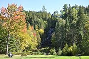 Wayside park in autumn 2016
 -
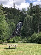
 Open area with picnic tables and rain shelter, autumn 2016


-
 The falls in autumn 2016
 -
 The falls in August 2019


References[edit]
- ^ "Beaver Brook Wayside Area". Geographic Names Information System. United States Geological Survey, United States Department of the Interior.
- ^ "Beaver Brook Falls". New England Waterfalls. Retrieved February 18, 2017.
- ^ "Beaver Brook Falls". Waterfalls of the Northeast United States. Retrieved February 18, 2017.
- ^ "Beaver Brook Falls Wayside". New Hampshire Division of Parks and Recreation. Retrieved July 29, 2020.
- ^ R, Mike (August 11, 2021). "New Hampshire 2024 Solar Eclipse State Parks". CosmosPNW. Retrieved October 3, 2022.
External links[edit]
Wikimedia Commons has media related to Beaver Brook Falls Wayside Park.
- Beaver Brook Falls Wayside New Hampshire Department of Natural and Cultural Resources