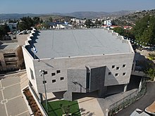
Beit El yeshiva
Appearance


The Beit El Yeshiva (Hebrew: ישיבת בית אל) is a Religious Zionist Yeshiva situated in the Israeli settlement of Beit El, a community in the Binyamin region near Ramallah in the Israeli-controlled Area C of the West Bank.
History
The Yeshiva was founded in late 1977 by a group of students from the Mercaz haRav yeshiva in Jerusalem. The students originally lived on a nearby army base, but today the yeshiva has its own premises, and over 250 students enrolled. The rosh yeshiva (dean) is Rabbi Zalman Baruch Melamed.
Arutz Sheva - Israel National News was founded and is maintained by the Beit El Yeshiva.[1] The Beit El Yeshiva also founded Yeshiva.co, a large Jewish website.[2]
The Beit El Yeshiva Center also includes:
- A yeshiva (religious studies) high school for boys (junior and senior yeshiva high school), Yeshivat Bnei Zvi,[2] also known as Bnei Zvi Yeshiva Ketana (pre-yeshiva high school; ketana stands for "small")[3]
- An ulpana (religious studies) high school for girls, Ulpanat Ra'aya[2]
- An ulpana high school for girls "with a wide variety of studies", Tal Ra'aya[2]
- A mechina pre-military program for young men[3]
References
- ^ "The Chief Rabbi of South Africa, Rabbi Warren Goldstein, is a graduate of the Beth El Yeshiva, the organization that founded and maintains Arutz Sheva."Goldstein, Rabbi Warren. "A Passover Message from the Chief Rabbi of South Africa". Arutz Sheva. Retrieved 1 April 2012.
- ^ a b c d Official site, Bet El Yeshiva Center
- ^ a b Arutz Sheva, 21/09/10
Further reading
- Maltz, Judy (17 January 2017). "Inside the Religious West Bank Settlement That Forged President Trump's Israel Policy". Haaretz.
External links
- Beit El Yeshiva Center Official Website
- Bet El Kabbalists by Pinchas Giller, Encyclopedia of Jews in the Islamic World entry, p 5 sq
