Borrowby, west North Yorkshire
This article possibly contains original research. (March 2015) |
| Borrowby | |
|---|---|
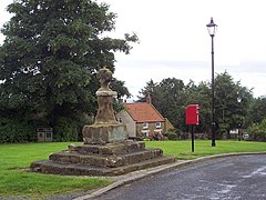
 The Market Cross (and Preaching Stone) at Borrowby | |
Location within North Yorkshire | |
| Population | 386 (Including Leake. 2011 census)[1] |
| OS grid reference | SE428892 |
| • London | 200 mi (320 km) S |
| Civil parish |
|
| Unitary authority | |
| Ceremonial county | |
| Region | |
| Country | England |
| Sovereign state | United Kingdom |
| Post town | THIRSK |
| Postcode district | YO7 |
| Police | North Yorkshire |
| Fire | North Yorkshire |
| Ambulance | Yorkshire |
Borrowby is a village and civil parish in North Yorkshire, England. It is situated halfway between Thirsk and Northallerton, about 25 miles (40 km) north of York, in the Vale of Mowbray, a low-lying agricultural landscape shaped by the last glaciation, that lies between two national parks, the North York Moors to the east and the Yorkshire Dales to the west.
Borrowby is one of the so-called Hillside Villages and can be found towards the eastern fringe of the vale where the land begins to rise to the moors. The village is said to be of Danish origin (ending –by) when it was some kind of stronghold. It was then mentioned in the 1086 Domesday Book[2] and other early records under various spellings of "Berghby" meaning 'village on a hill'.[3] This exposed location has always been good for growing orchards[4] as the hill tops escaped the glacial debris and cannot be reached by the flood plains of the river, the Cod Beck. Borrowby was once part of the parish of Leake, which is further north, and in the first half of the 19th century there was an extensive manufacture of linen.[4] Since 1978 the village has been a conservation area.[5]
The village grew in a linear form along the main road sloping upwards to the north. It is characteristic, that to the front the buildings are separated by a broad grass verge to the main road and the backs of the properties are associated with the adjoining long plots that are accessed via a back lane. A triangular street formation divides High Borrowby from Low Borrowby and acts as a village green and centre with a public house, (The Wheatsheaf Inn), village hall and church. On the village green is an old cross which is said to have marked the border between Borrowby and the town of Gueldable,[6] (and the two Wapentakes of Allerton and Birdforth) at a time when both townships were completely intermixed.[7]
It is clear[according to whom?] that the structure and character of the village have not significantly changed to this day, though some original cottages have been replaced by more modern versions and gaps between the buildings have been filled. There used to be a Primitive Methodist Chapel but today only the Methodist Church remains. On many of the old buildings traces of lime wash that coated the sandstone facades are still visible.[citation needed]
See also[edit]
References[edit]
- ^ UK Census (2011). "Local Area Report – Borrowby Parish (1170216807)". Nomis. Office for National Statistics. Retrieved 21 March 2018.
- ^ Powell-Smith, Anna. "Borrowby | Domesday Book". opendomesday.org. Retrieved 17 May 2018.
- ^ Ekwall, Eilert (1960). The concise Oxford dictionary of English place-names (4 ed.). Oxford: Clarendon Press. pp. 25, 53. ISBN 0-19-869103-3.
- ^ a b "Parishes: Leake | British History Online". www.british-history.ac.uk. Retrieved 17 May 2018.
- ^ "Conservation areas and listed buildings". www.hambleton.gov.uk. Retrieved 17 May 2018.
- ^ Grainge, William (1859). The Vale of Mowbray: a historical and topographical account of Thirsk and its neighbourhood (2 ed.). Ripon: Simpkin & Co. pp. 313–314. OCLC 559956399.
- ^ "Genuki: LEAKE: Geographical and Historical information from the year 1890., Yorkshire (North Riding)". www.genuki.org.uk. Retrieved 17 May 2018.
Further reading[edit]
- Grainge, William (1859); The Vale of Mowbray: A Historical and Topographical Account of Thirsk and Its Neighbourhood; G. H. Smith & Son, reprint 1993. ISBN 0904775887
- Bogg, Edmund; The Golden Vale of Mowbray, Elliot Stock; reprint edition (1909)
External links[edit]
 Media related to Borrowby, Hambleton at Wikimedia Commons
- The Borrowby Show
- Borrowby on the Thirsk website
- Borrowby on the National Flood Forum

