
Brnakot
Brnakot
Բռնակոթ | |
|---|---|
 St. Grigor Church in Brnakot | |
 Brnakot  Brnakot | |
| Coordinates: 39°29′49″N 45°58′23″E / 39.49694°N 45.97306°E | |
| Country | Armenia |
| Province | Syunik |
| Municipality | Sisian |
| Area | |
| • Total | 51.53 km2 (19.90 sq mi) |
| Population | |
| • Total | 1,960 |
| • Density | 38/km2 (99/sq mi) |
| Time zone | UTC+4 (AMT) |
| Brnakot at GEOnet Names Server | |
Brnakot (Armenian: Բռնակոթ) is a village in the Sisian Municipality of the Syunik Province in Armenia.
Demographics[edit]
The Statistical Committee of Armenia reported its population as 2,315 in 2010,[3] up from 2,103 at the 2001 census.[4]
Gallery[edit]
-
 Adonts families house
 -
 School
 -
 Statues of Liparit Israyelyan and Samson Mkrtumyan
 -
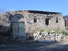
 St. Grigor Church in Brnakot
 -
 World war II monument
 -
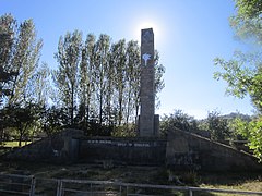 World war II monument


References[edit]
Wikimedia Commons has media related to Brnakot.
- ^ "Syunik regional e-Governance System" (in Armenian). Syunik Province provincial government. Click on link entitled "Համայնքներ" (community) and search for the place by Armenian name.
- ^ Statistical Committee of Armenia. "The results of the 2011 Population Census of Armenia" (PDF).
- ^ "Marzes of Armenia and Yerevan City in Figures, 2010" (PDF). Statistical Committee of Armenia.
- ^ Report of the results of the 2001 Armenian Census, Statistical Committee of Armenia

| International | |
|---|---|
| National | |
This article about a location in Syunik Province, Armenia is a stub. You can help Wikipedia by expanding it. |