
Cabo de Hornos National Park
| Cabo de Hornos National Park | |
|---|---|
 Satellite image of Hermite Islands | |
 | |
| Location | Tierra del Fuego, Chile |
| Nearest city | Puerto Williams |
| Coordinates | 55°49′59″S 67°25′59″W / 55.833°S 67.433°W |
| Area | 63,093 ha (155,906 acres)[1] |
| Established | April 26, 1945[2] |
| Visitors | 10,407[3] (in 2016) |
| Governing body | Corporación Nacional Forestal |
Cabo de Hornos National Park is a protected area in southern Chile that was designated a Biosphere Reserve by UNESCO in 2005,[4] along with Alberto de Agostini National Park. The world's southernmost national park,[5] it is located 12 hours by boat from Puerto Williams in the Cape Horn Archipelago, which belongs to the Commune of Cabo de Hornos in the Antártica Chilena Province of Magallanes y Antártica Chilena Region.
The park was created in 1945[2] and includes the Wollaston Islands and the Hermite Islands. It covers 63,093 hectares (155,906 acres)[1] and is run by the Corporacion Nacional Forestal (CONAF), the Chilean body that governs all national parks in Chile.[6]
Origins[edit]
The region of Cabo de Hornos (Cape Horn) was discovered by the Dutch merchant Isaac Le Maire on January 29, 1616, and was named Hoorn after the Dutch city where the expedition came from. The national park was created on April 26, 1945, by the Chilean Ministry of Agriculture.[2]
Geography[edit]
The park covers an area of 63,093 hectares (155,906 acres),[1] at a general altitude of 220 meters, with the exception of two major peaks: Cerro Pirámide, which has an altitude of 406 meters, and Cerro Hyde, the highest point with an altitude of 670 meters. It comprises a series of the islands and islets that make up the archipelago, including the main landmasses of the Wollaston and Hermite Islands.The park is the southernmost piece of Chilean territory, except for the Chilean Antarctic Territory which is in dispute.[7]
Climate[edit]
The climate in the park is generally cool, owing to the southern latitude. There are no clearly distinct weather stations, but a study in 1882–1883 found an annual rainfall of 1,357 millimetres (53.4 in), with an average annual temperature of 5.2 °C (41.4 °F). Winds were reported to average 30 kilometres per hour (8.33 m/s; 18.64 mph), (5 Bf), with squalls of over 100 kilometres per hour (27.78 m/s; 62.14 mph), (10 Bf) occurring in all seasons.[8] There are 278 days of rainfall (70 days of snow) and 2000 mm of annual rainfall[9]
Cloud coverage is generally extensive, with averages from 5.2 eighths in May and July to 6.4 eighths in December and January.[10][unreliable source?] Precipitation is high throughout the year: the weather station on the nearby Diego Ramirez Islands, 109 kilometres (68 miles) south-west in the Drake Passage, shows the greatest rainfall in March, averaging 137.4 millimetres (5.41 in); while October, which has the least rainfall, still averages 93.7 millimetres (3.69 in).[11][unreliable source?] Wind conditions are generally severe, particularly in winter. In summer, the wind at Cape Horn is gale force up to 5% of the time, with generally good visibility; however, in winter, gale-force winds occur up to 30% of the time, often with poor visibility.[12]
Flora[edit]
The terrain is almost entirely treeless peat and its main characteristic is the presence of tuberous vegetable formations covered in low dense Poaceaes (Gramineae), lichen and mosses that are resistant to the low temperatures and harsh weather. In some parts, small wooded areas of Antarctic beech or nire, lenga, winter's bark or canelo, and Magellanic coigüe can be found.[13]
Fauna[edit]
As with the flora, fauna in the park is scarce and many of the species are endangered. The fauna is dominated by birds and maritime mammals.[14] Bird species found on the islands include:[15] Magellanic penguin (Spheniscus magellanicus), or red peek penguin, the southern giant petrel (Macronectes giganteus), kelp gull or Dominican gull (Larus dominicanus), red-legged cormorant (Poikilocarbo gaimardi, also known as the red-legged shag, red-footed cormorant, red-footed shag, Gaimard's cormorant or grey cormorant),[16] and southern royal albatross (Diomedea epomophora).[17]
- Some of the birds species found in Cape Horn
-
 Southern giant petrel (Macronectes giganteus), also known as the Antarctic giant petrel, giant fulmar, stinker, and stinkpot.
 -
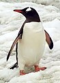 Antarctic penguin (Pygoscelis papua ellsworthi) also known as red peak penguin
 -
 Kelp gull (Larus dominicanus), also known as the Dominican gull
 -
 The Magellanic penguin (Spheniscus magellanicus)
 -
 Southern royal albatross (Diomedea epomophora)


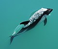
Mammal species found in the park include: marine otter (Lontra felina, known locally as chungungo), leopard seal (Hydrurga leptonyx), Chilean dolphin (Cephalorhynchus eutropia, also known as the black dolphin or tonina), Burmeister's porpoise (Phocoena spinipinnis), Peale's dolphin (Lagenorhynchus australis) and humpback whale (Megaptera novaeangliae).
- Some of Cabo de Hornos mammals
-
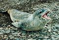 Leopard seal (Hydrurga leptonyx), also referred to as the sea leopard.
 -
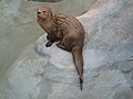 Marine otter or chungungo.
 -
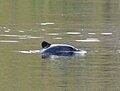 Chilean or black dolphin, also known as tonina
 -

-
 Peale's dolphin (Lagenorhynchus australis)


See also[edit]
References[edit]
- ^ a b c "National Parks of Chile". CONAF. Retrieved 2 April 2017.
- ^ a b c "Cabo de Hornos National Park". CONAF. Retrieved 2 April 2017.
- ^ "Visitor Statistics" (PDF). National Forest Corporation (Chile). 31 January 2017. p. 3. Retrieved 2 April 2017.
- ^ Cabo de Hornos UNESFO UNESCO 2009 - 2014, retrieved on December 16, 2014
- ^ Cape Horn The Encyclopedia of Earth 2014, retrieved on December 16, 2014
- ^ "Parque Nacional Cabo de Hornos". Corporacion Nacional Forestal. Archived from the original on 2012-08-07. Retrieved 2012-03-20.
- ^ "Frozen empires : a history of the Antarctic sovereignty dispute between Britain, Argentina, and Chile, 1939-1959" Digital Repository, University of Texas 2005 - 2008, retrieved on December 15, 2014
- ^ Opiliones from the Cape Horn Archipelago Archived 2007-09-30 at the Wayback Machine, James C. Cokendolpher and Dolly Lanfranco L.; from Texas Tech University, 1985. Retrieved February 5, 2006.
- ^ Rescate en el Cabo de Hornos Archived 2014-11-14 at the Wayback Machine, REPORTAJE HISTÓRICO: RESCATE EN EL CABO DE HORNOS, retrieved on December 15, 2014
- ^ Usuaia: Monthly Normals Archived 2018-11-06 at the Wayback Machine, from Weather Underground. Retrieved February 5, 2006.
- ^ Isla Diego Ramirez: Monthly Normals Archived 2018-11-06 at the Wayback Machine, from Weather Underground. Retrieved February 5, 2006.
- ^ U.S. Navy Marine Climatic Atlas of the World: Rounding Cape Horn, 1995. Retrieved February 5, 2006.
- ^ Cabo de Hornos National Park Archived 2014-12-21 at the Wayback Machine 2012 Tourismchile.com retrieved on December 14, 2014
- ^ La Patagonia: Especies en peligro (es) Archived 2014-12-21 at the Wayback Machine oceana.org 2014, Retrieved on December 16, 2014
- ^ Cape Horn Biosphere Reserve Archived 2014-10-22 at the Wayback Machine A Challenge for Biodiversity Conservation, and Implementation of Sustainable Development in Southernmost South America, Ricardo Rozzi, Francisca Massardo, Andrés Mansilla, Christopher B. Anderson, Augustin Berghöfer, Miguel Mansilla, María Rosa Gallardo, Jordi Plana, Uta Berghöfer, Ximena Arango, Shaun Russell, Pedro Araya & Eduardo Barros
- ^ Nelson, J. B. 2005. Cormorants and shags. Pages 512–14. In C. M. Perrins, W. J. Bock and J. Kikkawa, eds. Pelicans, Cormorants, and their Relatives. Oxford University Press, New York.
- ^ Albatros real, pajaro carnero rutaschile.com 2014, Retrieved on December 16, 2014