
Carrizozo volcanic field
| Carrizozo Volcanic Field | |
|---|---|
 | |
| Highest point | |
| Elevation | 1,565 to 1,730 m (5,135 to 5,676 ft)[1] |
| Coordinates | 33°42′10″N 105°56′17″W / 33.70278°N 105.93806°W[2] |
| Geography | |
| Location | Lincoln County, New Mexico, United States |
| Geology | |
| Mountain type | volcanic field |
| Volcanic arc/belt | Rio Grande Rift[3] |
| Last eruption | 3250 BCE ± 500 years[4] |
The Carrizozo volcanic field is a monogenetic volcanic field located in New Mexico, US. The volcanic field consists of two lava flows, the Broken Back flow and the Carrizozo lava flow (Carrizozo Malpais), the second youngest in New Mexico.[5] Both lava flows originated from groups of cinder cones. The Broken Back flow is approximately 16 kilometres (10 mi) long and the Carrizozo, one of the largest in the world, is 68 kilometres (42 mi) long, covering 328 square kilometres (127 sq mi) with a volume of 4.2 cubic kilometres (1.0 cu mi).[1]
Carrizozo Malpais[edit]

The Carrizozo Malpais is a large lava flow on the west side of Carrizozo, New Mexico, on the northern part of the Tularosa Basin between Sierra Blanca to the southeast and the Oscura Mountains to the west.
The lava making up the flow came from Little Black Peak, about 10 miles (16 km) north-northwest of Carrizozo. It reached about 40 miles (64 km) south-southwest along the bottom of Tularosa Basin in two active flows. Initial age estimates ranged from 1,000 to 1,500 years ago, but recent cosmogenic dating techniques revealed the eruption date is 5200 ± 700 years ago.[6] At their southern end, the lava flows are about 12 miles (19 km) north of the dune fields of White Sands National Park. The Carrizozo Woman's Club helped protect this state area.[7]
The lava flow is composed of pāhoehoe lava that spread through lava tubes. The eruptions are estimated to have lasted about three decades, and the extent of the flow reflects this long eruptive duration rather than a high eruption rate.[8]
The Valley of Fires Recreation Area provides access to the Malpaís on its east edge, about 3 miles (4.8 km) west of Carrizozo on U.S. Route 380.[9] The highway has several scenic overlooks where it crosses the Malpaís. The entire extent of the flow can be seen from higher elevations to the east on U.S. Route 380. The Trinity (nuclear test), first atomic bomb detonation site, is 20 miles (32 km) northwest.
Broken Back flow[edit]
The Broken Back flow erupted from vents (a north-trending fissure, Broken Back Crater, and an unnamed cinder cone) located about 10 kilometers (6 mi) northwest of Little Black Peak. The flow covered an area of about 50 square kilometers (20 sq mi) and is partially overlapped by the younger Carrizozo Malpais. This flow is significantly older than the Carrizozo Malpais, with an age estimated as 100,000 years, based on the degree of weathering and erosion.[10]
-
 The location of Carrizozo.
 -
 Satellite image of Carrizozo.
 -
 An overview of the lava flows (Little Black Peak in distance).
 -
 A close-up view of the lava flows, showing pahoēhoē (Hawaiian for "ropey") lava flow structure.
 -
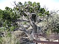 A western juniper tree grows out of the Carrizozo Malpaís.


Geology[edit]
The volcanic field is associated with the Rio Grande Rift, a region of the Earth's crust that is being slowly pulled apart. This produces faulting that provides paths for magma to reach the Earth's surface from its upper mantle.[10] The lavas erupted were mildly alkaline in composition, similar to the nearby Jornada del Muerto, Hillsboro, and Black Mesa (33°44′46″N 106°52′23″W / 33.746°N 106.873°W) flows.[11]
Seismic measurements in the region have detected a possible thermal anomaly associated with the volcanic field.[12]
Notable vents[edit]
| Name | Elevation | Coordinates | Last eruption |
| Broken Back Crater[2] | - | 33°49′56″N 106°04′01″W / 33.83219°N 106.06695°W | - |
| Little Black Peak[2] | - | 33°49′24″N 106°03′41″W / 33.82330°N 106.06137°W | - |
See also[edit]
- Jornada del Muerto
- Jornada del Muerto Volcano
- List of volcanoes in the United States
- Lava plain
- Malpaís (landform)
References[edit]
- ^ a b "Carrizozo, New Mexico". VolcanoWorld. Archived from the original on 2008-09-26. Retrieved 2008-08-15.
- ^ a b c Wood, Charles A.; Jűrgen Kienle (1993). Volcanoes of North America. Cambridge University Press. pp. 308–309. ISBN 0-521-43811-X.
- ^ "White Sands Geology". National Park Service. Archived from the original on October 12, 2006. Retrieved 2008-08-15.
- ^ "Geochronology of the Carrizozo Malpais". NMBGMR Geologic Tour - Carrizozo Malpais. New Mexico Bureau of Geology and Mineral Resources. 2008-05-29. Retrieved 2008-08-15.
- ^ "Carrizozo". Global Volcanism Program. Smithsonian Institution. Retrieved 2009-02-06.
- ^ Landmarks: "Geochronology of the Carrizozo Malpais", New Mexico Institute of Mining and Technology; Retrieved October 8, 2014.
- ^ Maue, Lisa (15 March 2016). "Carrizozo Woman's Club Has Deep Roots". Ruidoso News. Retrieved 13 February 2017.
- ^ Anthony, Elizabeth Y.; Hoffer, Jerry; Williams, Wendi J.; Poths, Jane; Penn, Brian (1998). "Geochemistry and geochronology of Quaternary mafic volcanic rocks in the vicinity of Carrizozo, New Mexico" (PDF). New Mexico Geological Society Field Conference Series. 49: 117–122. Retrieved 12 August 2021.
- ^ Crumpler, L.S.; Aubele, J.C. (2001). Volcanoes of New Mexico: an abbreviated guide for non-specialists. Vol. 18. Albuquerque: New Mexico Museum of Natural History and Science. p. 11. Retrieved 12 August 2021.
- ^ a b Anthony et al. 1998, p. 117.
- ^ Anthony et al. 1998, p. 117, 121.
- ^ West, Michael (2004). "Crust and upper mantle shear wave structure of the southwest United States: Implications for rifting and support for high elevation". Journal of Geophysical Research. 109 (B3): B03309. doi:10.1029/2003JB002575.