
Chester, Minnesota
Chester | |
|---|---|
 Chester Location of the community of Chester within Marion Township, Olmsted County  Chester Chester (the United States) | |
| Coordinates: 44°00′25″N 92°20′43″W / 44.00694°N 92.34528°W | |
| Country | United States |
| State | Minnesota |
| County | Olmsted |
| Township | Marion Township |
| Elevation | 1,138 ft (347 m) |
| Time zone | UTC-6 (Central (CST)) |
| • Summer (DST) | UTC-5 (CDT) |
| ZIP code | 55904 |
| Area code | 507 |
| GNIS feature ID | 641148[1] |
Chester is an unincorporated community in Marion Township, Olmsted County, Minnesota, United States. It is located immediately east of Rochester along U.S. Highway 14 near Olmsted County Roads 19 and 119. Chester Woods Park is nearby.
Chester was an early station outside Rochester, Minnesota, from which it took its name.[2] At some point in the late 1800s or early 1900s, this station was renamed to Haverhill, the township just to the north of Marion Township, perhaps to avoid confusion with Rochester.[3]
| Census | Pop. | Note | %± |
|---|---|---|---|
| 1880 | 59 | — | |
| U.S. Decennial Census[4] | |||
References[edit]
- ^ "Chester, Minnesota". Geographic Names Information System. United States Geological Survey, United States Department of the Interior.
- ^ Chicago and North Western Railway Company (1908). A History of the Origin of the Place Names Connected with the Chicago & North Western and Chicago, St. Paul, Minneapolis & Omaha Railways. p. 55.
- ^ Chicago and North Western Railway Company (1970). Central Division Timetable No.1 Effective Feb 1, 1970 (PDF). p. 9.
- ^ "Census of Population and Housing". Census.gov. Retrieved June 29, 2019.
Municipalities and communities of Olmsted County, Minnesota, United States | ||
|---|---|---|
| Cities | 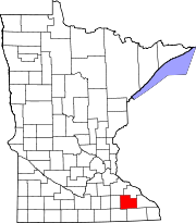 | |
| Townships | ||
| CDPs | ||
| Unincorporated communities | ||
| Footnotes | ‡This populated place also has portions in an adjacent county or counties | |