
Doi Inthanon National Park
| Doi Inthanon National Park | |
|---|---|
| อุทยานแห่งชาติดอยอินทนนท์ | |
 The Wachirathan Waterfall, Doi Inthanon National Park, the highest point in Thailand | |
 | |
| Location | Chom Thong District, Chiang Mai Province, Thailand |
| Coordinates | 18°35′32″N 98°29′12″E / 18.59222°N 98.48667°E |
| Area | 482 km2 (186 sq mi) |
| Established | 2 October 1972 [1] |
| Visitors | 874,372 (in 2019) |
| Governing body | Department of National Park, Wildlife and Plant Conservation (DNP) |
Doi Inthanon National Park (Thai: อุทยานแห่งชาติดอยอินทนนท์),[2] nicknamed "the roof of Thailand", is a national park in the Thanon Thong Chai Range, Chom Thong District, Chiang Mai Province, northern Thailand.[3] It includes Doi Inthanon, the country's highest mountain. It contains an area of 301,184 rai ~ 482 square kilometres (186 sq mi) in size.[4] It was established on October 2, 1972.[1]


Geography[edit]
The park is approximately 60 kilometres (37 mi) from Chiang Mai. It includes Karen and Meo Hmong villages of about 4,500 people.[5] Its elevation ranges between 800–2,565 metres (2,625–8,415 ft). Within its borders are a number of waterfalls: Mae Klang Falls, Wachiratan Falls, Siriphum Falls, and Mae Ya Falls.[3] The park has varied climatic and ecologically different sections.
Doi Inthanon National Park is located in a significant part of the Ping River watershed area, which has allowed numerous rivers to be formed, The Mae Wang, Mae Klang River, Maw Ya River, Mae Hoi River, Mae Chaem River, and Mae Tia Rivers being the most important one in the district.[6] These rivers will allow multiple local settlements in Chang Mai Province to be nourished before flowing into the Ping River.[6]
Flora[edit]
Flora includes evergreen cloud forest, sphagnum bog, and deciduous dipterocarp forest.[4] There are some relict pines.[3]
Plant communities of Doi Inthanon vary according to elevation. Below is a table of main plants by vegetation type:[7]
Fauna[edit]
With 383 avifauna species,[8] it ranks second among Thailand's national parks in number of bird species.[9]
-
 Subtropical semi-evergreen seasonal forest at the end of the dry season
 -
 Cethosia biblis, Doi Inthanon National Park
 -
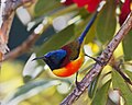 An adult male green-tailed sunbird


Reptile species in Doi Inthanon National Park include:[10]
- Acanthosaura lepidogaster
- Gekko gecko
- Hemidactylus frenatus
- Hemidactylus platyurus
- Hemiphyllodactylus chiangmaiensis
- Ahaetulla prasina
- Hebius khasiensis
- Trimeresurus popeiorum
- Cyrtodactylus inthanon[11]
Amphibian species in Doi Inthanon National Park include:[10]
- Ansonia inthanon
- Leptolalax pelodytoides
- Megophrys major
- Megophrys minor
- Amolops marmoratus
- Hylarana nigrovittata
- Odorrana livida
Gallery[edit]
-
 View from Inthanon peak
 -
 The viewpoint at the 41st km of the Highway 1009, Doi Inthanon
 -
 Doi Inthanon National Park
 -
 Doi Inthanon National Park
 -
 Cherry blossom flowers all over the area at Doi Inthanon National Park
 -
 A scenic walkway in the area of Doi Inthanon National Park
 -
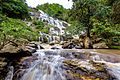 Mae Ya Waterfall in Doi Inthanon National Park
 -
 Siri Phum Waterfall in Doi Inthanon National Park
 -
 Siri Than Waterfall in Doi Inthanon National Park
 -
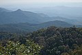
 Vegetation on the slopes of Doi Inthanon
 -
 Stream in the mountains


.jpg)


Location[edit]
| Doi Inthanon National Park in overview PARO 16 (Chiang Mai) | ||||||||||||||||||||||||||||||||||||||||||||||||||||||||||
_EN.svg)
|
See also[edit]
References[edit]
- ^ a b Doi Inthanon National Park The Royal Gazette
- ^ Pronunciation
- ^ a b c "Doi Inthanon National Park". Tourism Authority of Thailand (TAT). Archived from the original on 1 May 2015. Retrieved 1 May 2015.
- ^ a b "Jungle Law in Thailand's Forests". New Scientist. 18 Nov 1989. pp. 43–. ISSN 0262-4079. Retrieved 20 Nov 2014.
- ^ Zeppel, Heather (2006). Indigenous Ecotourism: Sustainable Development and Management. CABI. pp. 237–. ISBN 978-1-84593-124-7. Retrieved 1 Oct 2011.
- ^ a b "Doi Inthanon National Park, Chiang Mai Province, northern Thailand". Medium. Medium. Retrieved 27 November 2023.
- ^ Chayamarit, Kongkanda and Christian Puff (2007). Plants of Doi Inthanon National Park. Bangkok: National Park Office, Ministry of Natural Resources and Environment.
- ^ Poultney, Trevor (1 Jan 2003). Environments: Asia Pacific. Curriculum Press. pp. 22–. ISBN 978-1-86366-567-4. Retrieved 1 Oct 2011.
- ^ Elliot, Stephan; Cubitt, Gerald (2001). THE NATIONAL PARKS and other Wild Places of THAILAND. New Holland Publishers (UK) Ltd. pp. 62–67. ISBN 9781859748862.
- ^ a b Kirati Kunya, Montri Sumontha, Nonn Panitvong, Wuttipong Dongkumfu, Thana Sirisamphan and Olivier S. G. Pauwels. 2015. A New Forest-dwelling Bent-toed Gecko (Squamata: Gekkonidae: Cyrtodactylus) from Doi Inthanon, Chiang Mai Province, northern Thailand. Zootaxa. 3905(4):573-584. [p.579] DOI: 10.11646/zootaxa.3905.4.9
- ^ "Species New to Science: [Herpetology • 2015] Cyrtodactylus inthanon | ตุ๊กกายดอยอินทนนท์ | Doi Inthanon Bent-toed Gecko • A New Forest-dwelling Bent-toed Gecko (Squamata: Gekkonidae: Cyrtodactylus) from Doi Inthanon, Chiang Mai Province, northern Thailand". 16 January 2015.
External links[edit]
 Doi Inthanon National Park travel guide from Wikivoyage
- thaibirding.com on Doi Inthanon
- Betz, H., Srisanga, P., Suksathan, P. (2014). Doi Inthanon National Park, Chiang Mai, Northern Thailand, Selected Plants of Doi Inthanon
| International | |
|---|---|
| National | |