
File:1789 Dist. Cts..JPG
No higher resolution available.
1789_Dist._Cts..JPG (299 × 383 pixels, file size: 17 KB, MIME type: image/jpeg)
| This is a file from the Wikimedia Commons. Information from its description page there is shown below. Commons is a freely licensed media file repository. You can help. |
Summary
| Description |
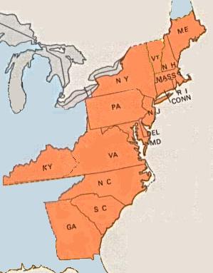
English: Map of the United States district courts established by the United States Congress through the Judiciary Act of 1789. District and state boundaries were concurrent, although Virginia and Massachusetts each had two districts within its bounds. Massachusetts was divided into the District of Maine (which was then part of Massachusetts) and the District of Massachusetts (which covered present-day Massachusetts). Virginia was divided into the District of Kentucky (which was then part of Virginia) and the District of Virginia (which covered present-day Virginia and West Virginia). |
| Date | |
| Source | Own work |
| Author | BD2412 |
Licensing
| I, the copyright holder of this work, release this work into the public domain. This applies worldwide. In some countries this may not be legally possible; if so: I grant anyone the right to use this work for any purpose, without any conditions, unless such conditions are required by law. |
File history
Click on a date/time to view the file as it appeared at that time.
| Date/Time | Thumbnail | Dimensions | User | Comment | |
|---|---|---|---|---|---|
| current | 18:07, 23 March 2009 | | 299 × 383 (17 KB) | BD2412 | {{Information |Description={{en|1=Map of the United States district courts to which George Washington appointed judges.}} |Source=Own work by uploader |Author=BD2412 |Date=2009-03-23 |Permission= |other_versions= }} <!--{{ImageUpload|full |
File usage
The following pages on the English Wikipedia use this file (pages on other projects are not listed):
Global file usage
The following other wikis use this file:
- Usage on it.wikipedia.org