
File:1837 Malte-Brun Map of China and Japan - Geographicus - China-mb-1837.jpg

Size of this preview: 794 × 600 pixels. Other resolutions: 318 × 240 pixels | 636 × 480 pixels | 1,017 × 768 pixels | 1,280 × 967 pixels | 2,328 × 1,758 pixels.
Original file (2,328 × 1,758 pixels, file size: 772 KB, MIME type: image/jpeg)
| This is a file from the Wikimedia Commons. Information from its description page there is shown below. Commons is a freely licensed media file repository. You can help. |
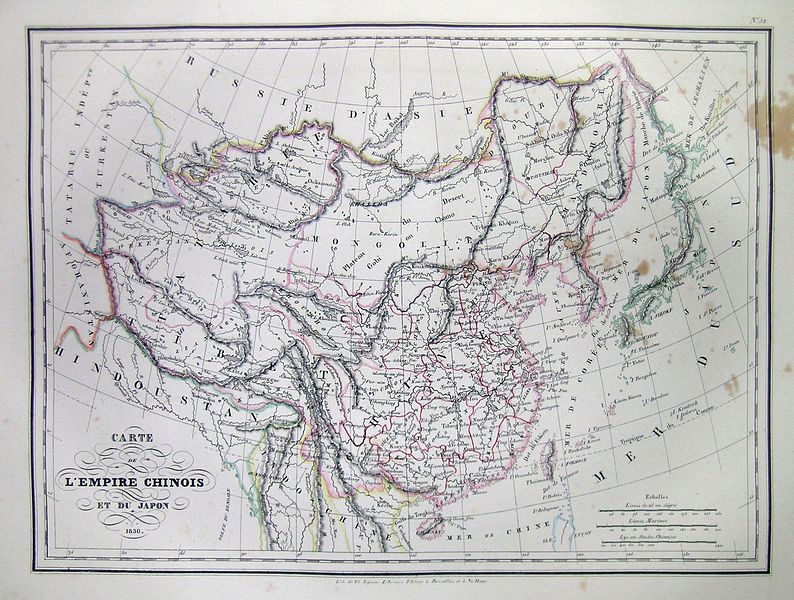
| Carte de L’Empire Chinois de Du Japon 1836. | ||||||
|---|---|---|---|---|---|---|
| Artist | ||||||
| Title |
Carte de L’Empire Chinois de Du Japon 1836. |
|||||
| Description |
English: This is a beautiful 1836 Hand colored map of China and Japan. Includes Tartary and the Mongol Empire. All text is in French. |
|||||
| Date | 1837 | |||||
| Dimensions | height: 9 in (22.8 cm); width: 12 in (30.4 cm) | |||||
| Accession number |
Geographicus link: China-mb-1837 |
|||||
| Source/Photographer |
|
|||||
| Permission (Reusing this file) |
|
|||||
| Other versions | ||||||
_in_1837_from_Malte-Brun_Map_of_China_and_Japan_(cropped).jpg)
| Annotations | This image is annotated: View the annotations at Commons |
File history
Click on a date/time to view the file as it appeared at that time.
| Date/Time | Thumbnail | Dimensions | User | Comment | |
|---|---|---|---|---|---|
| current | 11:39, 16 March 2011 | | 2,328 × 1,758 (772 KB) | BotMultichill | {{subst:User:Multichill/Geographicus |link=http://www.geographicus.com/P/AntiqueMap/China-mb-1837 |product_name=1837 Malte-Brun Map of China and Japan |map_title=Carte de L’Empire Chinois de Du Japon 1836. |description=This is a beautiful 1836 Hand co |
File usage
The following pages on the English Wikipedia use this file (pages on other projects are not listed):
Global file usage
The following other wikis use this file:
- Usage on ca.wikipedia.org
- Usage on fr.wikipedia.org