
File:2012 Hama Offensive.svg

Size of this PNG preview of this SVG file: 731 × 600 pixels. Other resolutions: 293 × 240 pixels | 585 × 480 pixels | 936 × 768 pixels | 1,248 × 1,024 pixels | 2,497 × 2,048 pixels | 1,430 × 1,173 pixels.
Original file (SVG file, nominally 1,430 × 1,173 pixels, file size: 2.15 MB)
| This is a file from the Wikimedia Commons. Information from its description page there is shown below. Commons is a freely licensed media file repository. You can help. |
Summary
| Description |
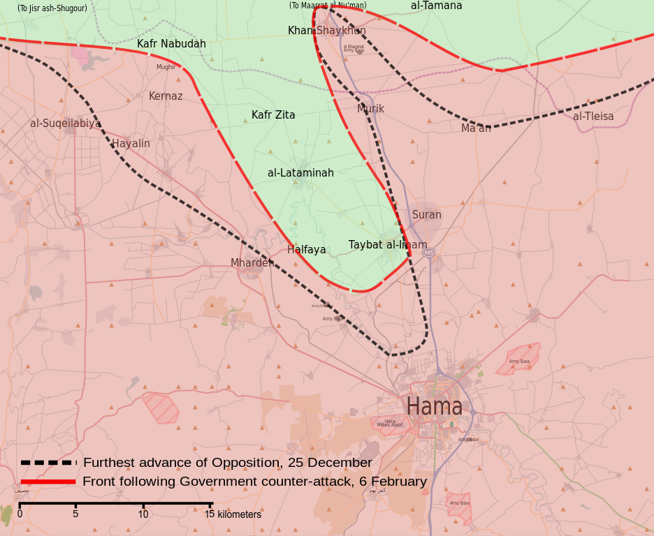
English: Map showing the frontlines during the 2012 Hama Offensive.
العربية: خريطة تظهر خطوط الجبهات خلال هجوم حماة 2012. |
| Date | |
| Source | Own work |
| Author | MrPenguin20 |
Licensing
| This work contains information from OpenStreetMap, which is made available under the Open Database License (ODbL).
The ODbL does not require any particular license for maps produced from ODbL data. Prior to 1 August 2020, map tiles produced by the OpenStreetMap Foundation were licensed under the CC-BY-SA-2.0 license. Maps produced by other people may be subject to other licences. |
I, the copyright holder of this work, hereby publish it under the following license:
This file is licensed under the Creative Commons Attribution-Share Alike 3.0 Unported license.
- You are free:
- to share – to copy, distribute and transmit the work
- to remix – to adapt the work
- Under the following conditions:
- attribution – You must give appropriate credit, provide a link to the license, and indicate if changes were made. You may do so in any reasonable manner, but not in any way that suggests the licensor endorses you or your use.
- share alike – If you remix, transform, or build upon the material, you must distribute your contributions under the same or compatible license as the original.
File history
Click on a date/time to view the file as it appeared at that time.
| Date/Time | Thumbnail | Dimensions | User | Comment | |
|---|---|---|---|---|---|
| current | 13:58, 15 September 2013 | | 1,430 × 1,173 (2.15 MB) | MrPenguin20 | Marked several army bases on map. |
| 22:37, 6 September 2013 |  | 1,430 × 1,173 (2.14 MB) | MrPenguin20 | Moved frontline closer to al-Tamana. | |
| 21:59, 6 September 2013 |  | 1,430 × 1,173 (2.14 MB) | MrPenguin20 | Marked army base south of Khan Shaykhun. | |
| 21:04, 6 September 2013 |  | 1,430 × 1,173 (2.14 MB) | MrPenguin20 | Changed frontline surrounding northern section of Hama-Khan Shaykhun highway. | |
| 01:19, 26 August 2013 |  | 1,430 × 1,173 (2.14 MB) | MrPenguin20 | User created page with UploadWizard |
File usage
The following pages on the English Wikipedia use this file (pages on other projects are not listed):
Global file usage
The following other wikis use this file:
- Usage on ar.wikipedia.org
- Usage on fa.wikipedia.org
- Usage on fr.wikipedia.org
- Usage on id.wikipedia.org
- Usage on pl.wikipedia.org
- Usage on pt.wikipedia.org
- Usage on www.wikidata.org
- Usage on zh.wikipedia.org