
File:Antipodes equirectangular.svg

Size of this PNG preview of this SVG file: 800 × 400 pixels. Other resolutions: 320 × 160 pixels | 640 × 320 pixels | 1,024 × 512 pixels | 1,280 × 640 pixels | 2,560 × 1,280 pixels | 1,800 × 900 pixels.
Original file (SVG file, nominally 1,800 × 900 pixels, file size: 83 KB)
| This is a file from the Wikimedia Commons. Information from its description page there is shown below. Commons is a freely licensed media file repository. You can help. |
Summary
| Description |
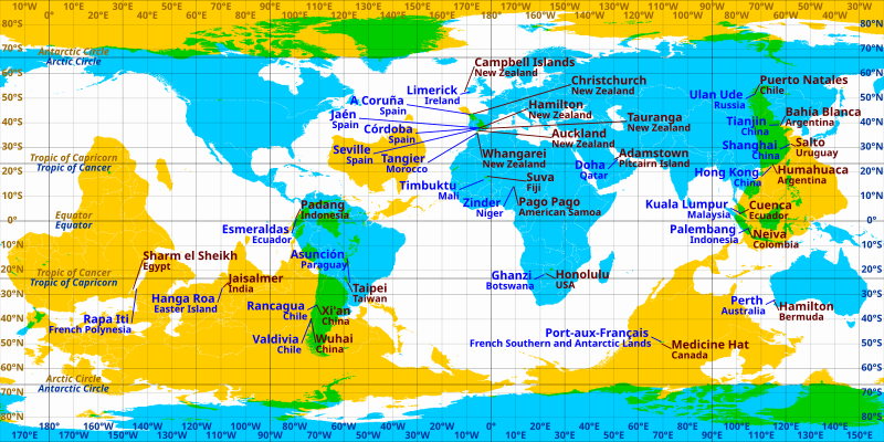
English: Cities and towns which are near antipodes in equirectangular projection. Blue labels correspond to the cyan areas and brown labels correspond to the yellow areas. Areas where blue and yellow overlap (coloured green) are land antipodes. |
| Source | Own work |
| Author | Cmglee |
| Other versions | File:Antipodes LAEA.png, File:Antipodes LAEA inverted.png, File:WorldMapWithAntipodes.png, |
Licensing
I, the copyright holder of this work, hereby publish it under the following license:
This file is licensed under the Creative Commons Attribution-Share Alike 3.0 Unported license.
- You are free:
- to share – to copy, distribute and transmit the work
- to remix – to adapt the work
- Under the following conditions:
- attribution – You must give appropriate credit, provide a link to the license, and indicate if changes were made. You may do so in any reasonable manner, but not in any way that suggests the licensor endorses you or your use.
- share alike – If you remix, transform, or build upon the material, you must distribute your contributions under the same or compatible license as the original.
File history
Click on a date/time to view the file as it appeared at that time.
| Date/Time | Thumbnail | Dimensions | User | Comment | |
|---|---|---|---|---|---|
| current | 10:27, 19 May 2011 | | 1,800 × 900 (83 KB) | AnonMoos | trivial changes to increase default display size, remove unused code |
| 23:27, 24 March 2011 |  | 512 × 256 (91 KB) | Cmglee | Move labels to reduce overlap, add new places and brighten bitmap. | |
| 08:50, 24 March 2011 |  | 512 × 256 (89 KB) | Cmglee | {{Information |Description ={{en|1=Cities and towns which are near antipodes in equirectangular projection. }} |Source ={{own}} |Author =Cmglee |Date = |Permission = |other_versions = }} [[Category:Maps of |
File usage
The following pages on the English Wikipedia use this file (pages on other projects are not listed):
Global file usage
The following other wikis use this file: