
File:Australia Victoria Southern Grampians Shire location map.svg

Size of this PNG preview of this SVG file: 533 × 491 pixels. Other resolutions: 261 × 240 pixels | 521 × 480 pixels | 834 × 768 pixels | 1,112 × 1,024 pixels | 2,223 × 2,048 pixels.
Original file (SVG file, nominally 533 × 491 pixels, file size: 640 KB)
| This is a file from the Wikimedia Commons. Information from its description page there is shown below. Commons is a freely licensed media file repository. You can help. |
| Description |
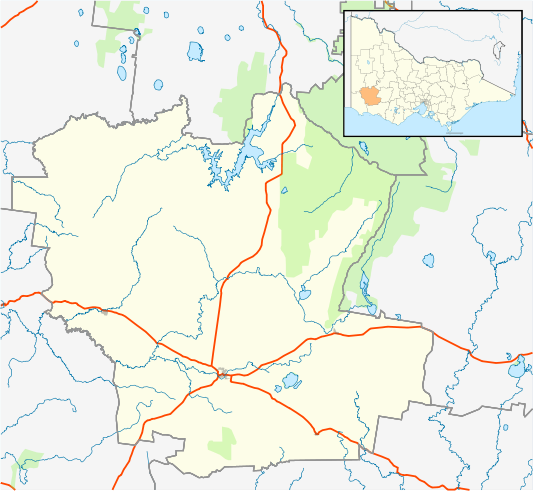
English: Blank map of w:Southern Grampians Shire, Victoria, Australia, with the following information shown:
Geographic limits:
|
||
| Source | Own work + VicMap Lite | ||
| Author | Cassowary |

File history
Click on a date/time to view the file as it appeared at that time.
| Date/Time | Thumbnail | Dimensions | User | Comment | |
|---|---|---|---|---|---|
| current | 16:00, 18 February 2011 | | 533 × 491 (640 KB) | Cassowary | {{Information |Description ={{en|1=Blank map of w:Southern Grampians Shire, Victoria, Australia, with the following information shown: * LGA boundaries * Coastline, lakes and rivers * Highways and freeways * Urban areas * Parks Geographic limits: |
File usage
The following pages on the English Wikipedia use this file (pages on other projects are not listed):
- Balmoral, Victoria
- Bochara, Victoria
- Branxholme, Victoria
- Brit Brit, Victoria
- Byaduk
- Cavendish, Victoria
- Coleraine, Victoria
- Dunkeld, Victoria
- Glenthompson, Victoria
- Gringegalgona, Victoria
- Hamilton, Victoria
- Konongwootong
- Penshurst, Victoria
- Pigeon Ponds
- Shire of Southern Grampians
- Tabor, Victoria
- Tahara, Victoria
- Tarrington, Victoria
- User:ThylacineHunter/LGA
- User:Viatori/sandbox
- Template:Towns in Southern Grampians Shire
- Module:Location map/data/Australia Victoria Shire of Southern Grampians
- Module:Location map/data/Australia Victoria Shire of Southern Grampians/doc
Global file usage
The following other wikis use this file:
- Usage on ar.wikipedia.org
- Usage on ceb.wikipedia.org
- Usage on fa.wikipedia.org
- Usage on kn.wikipedia.org
- Usage on si.wikipedia.org
- Usage on tr.wikipedia.org
- Usage on uz.wikipedia.org
- Usage on war.wikipedia.org