
File:Axial Seamount bathymetry.jpg

Size of this preview: 468 × 599 pixels. Other resolutions: 187 × 240 pixels | 478 × 612 pixels.
Original file (478 × 612 pixels, file size: 86 KB, MIME type: image/jpeg)
| This is a file from the Wikimedia Commons. Information from its description page there is shown below. Commons is a freely licensed media file repository. You can help. |
Summary
| Description |
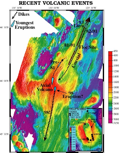
English: Full bathymetric of Axial Seamount. |
| Source | Direct link |
| Author | NOAA |
| Other versions | File:Axail Seamount NRZ.jpg |
Licensing
This image is in the public domain because it contains materials that originally came from the U.S. National Oceanic and Atmospheric Administration, taken or made as part of an employee's official duties.
|
File history
Click on a date/time to view the file as it appeared at that time.
| Date/Time | Thumbnail | Dimensions | User | Comment | |
|---|---|---|---|---|---|
| current | 03:08, 11 October 2010 | | 478 × 612 (86 KB) | Resident Mario | == Summary == {{Information |Description={{en|1=Full bathymetric of Axial Seamount.}} |Source=[http://www.pmel.noaa.gov/vents/nemo1998/images/lava.jpg Direct link] |Author=NOAA |Date= |Permission= |other_versions=[ |
File usage
The following pages on the English Wikipedia use this file (pages on other projects are not listed):