
File:Comino-Malta.png

Size of this preview: 800 × 411 pixels. Other resolutions: 320 × 164 pixels | 640 × 329 pixels | 1,024 × 526 pixels | 1,954 × 1,004 pixels.
Original file (1,954 × 1,004 pixels, file size: 631 KB, MIME type: image/png)
| This is a file from the Wikimedia Commons. Information from its description page there is shown below. Commons is a freely licensed media file repository. You can help. |
Summary
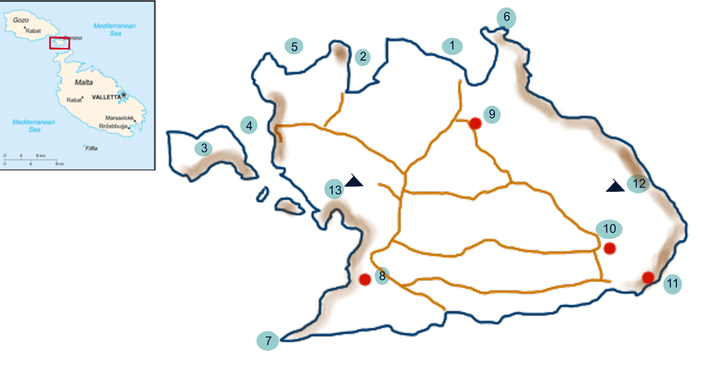
| Description | Plano esquematico de la isla de Comino, incluye plano de ubicacion Image:Mt-map.png de Commons ⋅ |
| Date | |
| Source | Own work |
| Author | Antur |
Referencias
- Bahía de San Nicolas
- Bahía de Santa María
- Islote Cominotto
- Lago Azul
- Ghar Ghana
- Ghemieri
- Ras-I-Irqlega
- Torre de Santa María
- Capilla de la Anunciación
- Granja de cerdos
- Refuerzo batería (ruinas)
- Máxima altura (47 m.s.m)
- Monte (47 m.s.m)
Se indican los senderos, y en marron sobre las costas las zonas de acantilados.
Licensing
I, the copyright holder of this work, hereby publish it under the following licenses:

|
Permission is granted to copy, distribute and/or modify this document under the terms of the GNU Free Documentation License, Version 1.2 or any later version published by the Free Software Foundation; with no Invariant Sections, no Front-Cover Texts, and no Back-Cover Texts. A copy of the license is included in the section entitled GNU Free Documentation License. |
| This file is licensed under the Creative Commons Attribution-Share Alike 3.0 Unported license. | ||
| ||
| This licensing tag was added to this file as part of the GFDL licensing update. |
This file is licensed under the Creative Commons Attribution-Share Alike 2.5 Generic, 2.0 Generic and 1.0 Generic license.
- You are free:
- to share – to copy, distribute and transmit the work
- to remix – to adapt the work
- Under the following conditions:
- attribution – You must give appropriate credit, provide a link to the license, and indicate if changes were made. You may do so in any reasonable manner, but not in any way that suggests the licensor endorses you or your use.
- share alike – If you remix, transform, or build upon the material, you must distribute your contributions under the same or compatible license as the original.
You may select the license of your choice.
File history
Click on a date/time to view the file as it appeared at that time.
| Date/Time | Thumbnail | Dimensions | User | Comment | |
|---|---|---|---|---|---|
| current | 19:05, 28 April 2007 | | 1,954 × 1,004 (631 KB) | Antur | {{Information: |Description: Plano esquematico de la isla de Comino, incluye plano de ubicacion Mt-map.png de Commons ⋅ |Source=self-made |Date= 28 de abril de 2007 |Author= User:Antur }} Category:Malta |
File usage
The following pages on the English Wikipedia use this file (pages on other projects are not listed):
Global file usage
The following other wikis use this file: