
File:Disused RAF training facility and a Spitfire - geograph.org.uk - 507432.jpg
No higher resolution available.
Disused_RAF_training_facility_and_a_Spitfire_-_geograph.org.uk_-_507432.jpg (640 × 480 pixels, file size: 43 KB, MIME type: image/jpeg)
| This is a file from the Wikimedia Commons. Information from its description page there is shown below. Commons is a freely licensed media file repository. You can help. |
Summary
| Description |
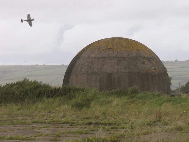
English: Disused RAF training facility and a Spitfire What can I say? I only stopped to take a picture for my own records of this training dome (a forerunner of today's flight simulators) as a result of Mike Williams' first Geograph of this architectural relic. At first I assumed the plane that flew into focus of my first picture taken of the dome was an RAF training plane but the aircraft's distinctive profile suggested it looked remarkably like a Spitfire.
Indeed, that's what it turned out to be. There was a Battle of Britain Memorial Flight taking place from nearby Pembrey airfield just as I was passing and happened to stop to take my picture. What a lovely looking and agile aircraft the Spitfire was! |
| Date | |
| Source | From geograph.org.uk |
| Author | Hywel Williams |
| Attribution (required by the license) | Hywel Williams / Disused RAF training facility and a Spitfire / |
| Camera location | | View this and other nearby images on: OpenStreetMap |
|---|
_heading:315.00&language=en)
| Object location | | View this and other nearby images on: OpenStreetMap |
|---|
_heading:315.00&language=en)
Licensing

|
This image was taken from the Geograph project collection. See this photograph's page on the Geograph website for the photographer's contact details. The copyright on this image is owned by Hywel Williams and is licensed for reuse under the Creative Commons Attribution-ShareAlike 2.0 license.
|
This file is licensed under the Creative Commons Attribution-Share Alike 2.0 Generic license.
Attribution: Hywel Williams
- You are free:
- to share – to copy, distribute and transmit the work
- to remix – to adapt the work
- Under the following conditions:
- attribution – You must give appropriate credit, provide a link to the license, and indicate if changes were made. You may do so in any reasonable manner, but not in any way that suggests the licensor endorses you or your use.
- share alike – If you remix, transform, or build upon the material, you must distribute your contributions under the same or compatible license as the original.
File history
Click on a date/time to view the file as it appeared at that time.
| Date/Time | Thumbnail | Dimensions | User | Comment | |
|---|---|---|---|---|---|
| current | 08:15, 5 February 2011 | | 640 × 480 (43 KB) | GeographBot | == {{int:filedesc}} == {{Information |description={{en|1=Disused RAF training facility and a Spitfire What can I say? I only stopped to take a picture for my own records of this training dome (a forerunner of today's flight simulators) as a result of Mik |
File usage
The following pages on the English Wikipedia use this file (pages on other projects are not listed):