
File:Ethiopian Railways.png
Size of this preview: 708 × 600 pixels. Other resolutions: 283 × 240 pixels | 567 × 480 pixels | 793 × 672 pixels.
Original file (793 × 672 pixels, file size: 1,001 KB, MIME type: image/png)
| This is a file from the Wikimedia Commons. Information from its description page there is shown below. Commons is a freely licensed media file repository. You can help. |

|
This transport map image could be re-created using vector graphics as an SVG file. This has several advantages; see Commons:Media for cleanup for more information. If an SVG form of this image is available, please upload it and afterwards replace this template with
{{vector version available|new image name}}.
It is recommended to name the SVG file “Ethiopian Railways.svg”—then the template Vector version available (or Vva) does not need the new image name parameter. |
Summary
| Description |
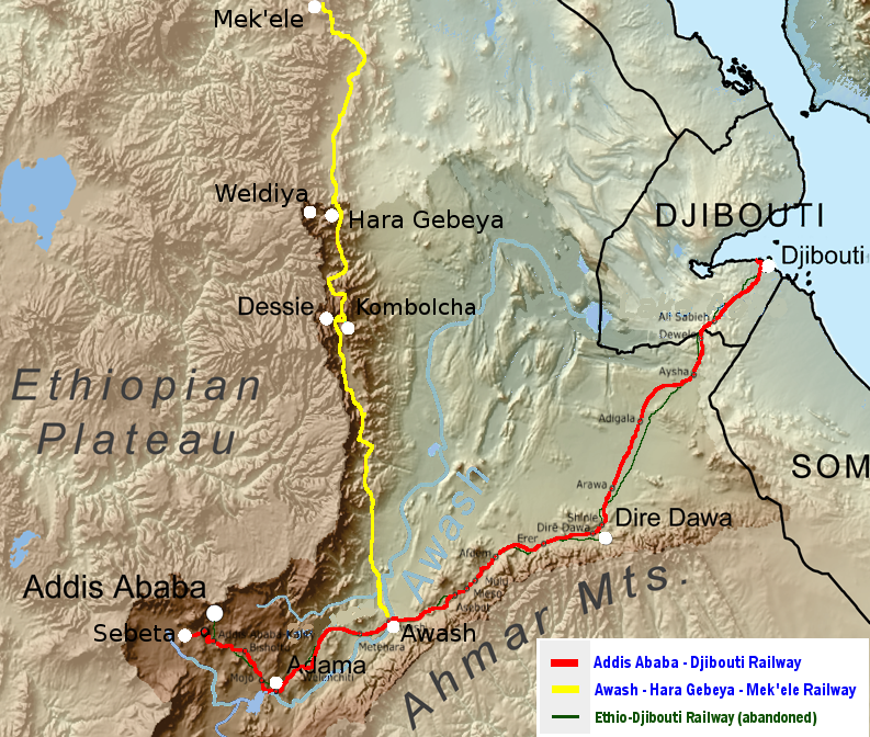
English: Map of the railways of Ethiopia in different colors. All railways are running for most of their course along one of the two escarpments of the Ethiopian Highlands and within the basins of the Afar Triangle and of the Awash River drainage basin (the latter indicated through darker colors / shades).
Addis Ababa–Djibouti Railway (operational as of 2018)
Awash–Hara Gebeya–Mek'ele Railways (under construction as of 2018)
Ethio–Djibouti Railway (partially abandoned) |
| Date | |
| Source |
This file was derived from: Awashrivermap.png |
| Author | metrancya |
Licensing
I, the copyright holder of this work, hereby publish it under the following license:
This file is licensed under the Creative Commons Attribution-Share Alike 4.0 International license.
- You are free:
- to share – to copy, distribute and transmit the work
- to remix – to adapt the work
- Under the following conditions:
- attribution – You must give appropriate credit, provide a link to the license, and indicate if changes were made. You may do so in any reasonable manner, but not in any way that suggests the licensor endorses you or your use.
- share alike – If you remix, transform, or build upon the material, you must distribute your contributions under the same or compatible license as the original.
File history
Click on a date/time to view the file as it appeared at that time.
| Date/Time | Thumbnail | Dimensions | User | Comment | |
|---|---|---|---|---|---|
| current | 12:31, 6 December 2017 | | 793 × 672 (1,001 KB) | Metrancya | added a description for the abandoned Ethio-Djibouti Railway |
| 22:28, 5 December 2017 |  | 793 × 672 (998 KB) | Metrancya | =={{int:filedesc}}== {{Information |description={{en|1=Map of the two railways of Ethiopia in different colors. The two railways are mostly running along the two escarpments of the Highland of Ethiopia within the Afar Triangle (mostly the Awash River d... |
File usage
The following pages on the English Wikipedia use this file (pages on other projects are not listed):
Global file usage
The following other wikis use this file:
- Usage on cs.wikipedia.org
- Usage on de.wikipedia.org
- Usage on es.wikipedia.org
- Usage on fi.wikipedia.org
- Usage on he.wikivoyage.org
- Usage on ru.wikipedia.org
- Usage on sv.wikipedia.org
- Usage on www.wikidata.org