
File:GreaterAmericaMap.jpg

Size of this preview: 800 × 558 pixels. Other resolutions: 320 × 223 pixels | 640 × 446 pixels | 1,024 × 714 pixels | 1,280 × 893 pixels | 1,537 × 1,072 pixels.
Original file (1,537 × 1,072 pixels, file size: 325 KB, MIME type: image/jpeg)
| This is a file from the Wikimedia Commons. Information from its description page there is shown below. Commons is a freely licensed media file repository. You can help. |

|
This locator map image could be re-created using vector graphics as an SVG file. This has several advantages; see Commons:Media for cleanup for more information. If an SVG form of this image is available, please upload it and afterwards replace this template with
{{vector version available|new image name}}.
It is recommended to name the SVG file “GreaterAmericaMap.svg”—then the template Vector version available (or Vva) does not need the new image name parameter. |


Summary
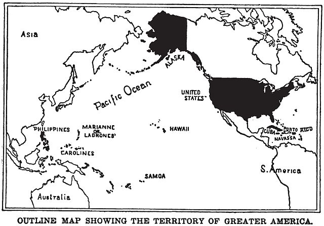
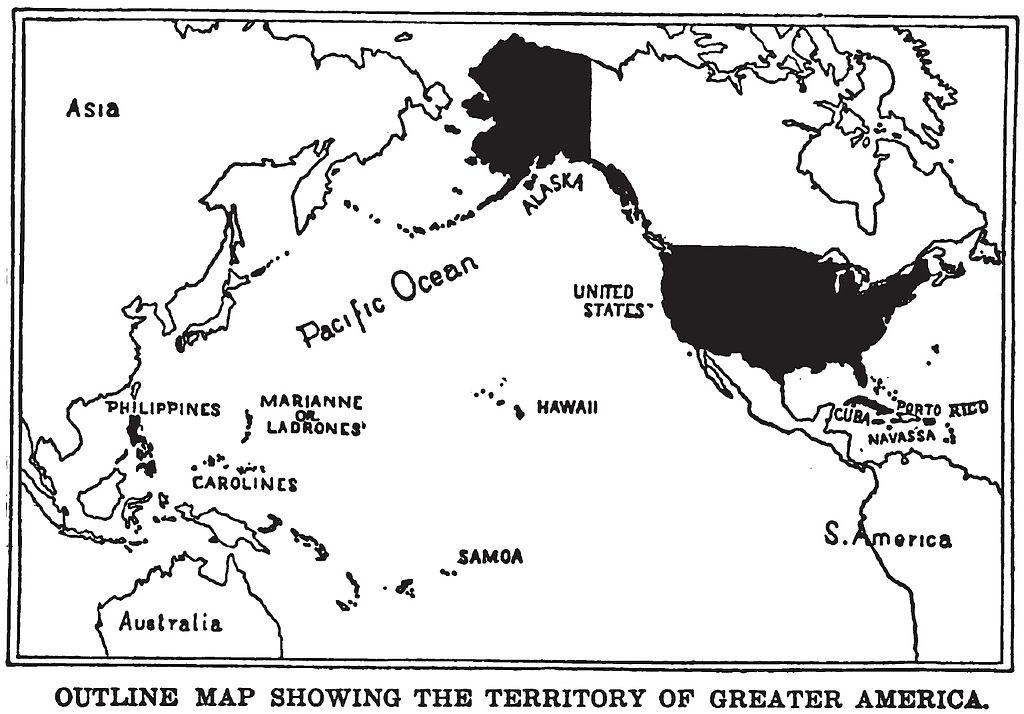
English: Map of "Greater America", 1899.
Shows territories and possessions of the United States after the Spanish American War, including Alaska, Cuba, Hawaii, Marianas, Philippines, Puerto Rico, and Samoa in addition to the continental United States.
Printed in book "War in the Philippines" by Marshall Everet.
Scanned from original 1899 printing by Infrogmation, previously uploaded by him to en:Wikipedia 23:36, 22 October 2003
en:Image:GreaterAmericaMap.jpg
Licensing
This media file is in the public domain in the United States. This applies to U.S. works where the copyright has expired, often because its first publication occurred prior to January 1, 1929, and if not then due to lack of notice or renewal. See this page for further explanation.
|
 | |
 |
This image might not be in the public domain outside of the United States; this especially applies in the countries and areas that do not apply the rule of the shorter term for US works, such as Canada, Mainland China (not Hong Kong or Macao), Germany, Mexico, and Switzerland. The creator and year of publication are essential information and must be provided. See Wikipedia:Public domain and Wikipedia:Copyrights for more details.
|
File history
Click on a date/time to view the file as it appeared at that time.
| Date/Time | Thumbnail | Dimensions | User | Comment | |
|---|---|---|---|---|---|
| current | 22:17, 24 August 2010 | | 1,537 × 1,072 (325 KB) | Quazgaa | Higher Res |
| 12:55, 23 May 2005 |  | 571 × 391 (70 KB) | Shizhao | Map of "Greater America", scanned from 1899 book. Shows territories and possessions of the United States after the Spanish American War, including Alaska, Cuba, Hawaii, Marianas, Philippines, Puerto Rico, and Samoa |
File usage
The following pages on the English Wikipedia use this file (pages on other projects are not listed):
Global file usage
The following other wikis use this file:
- Usage on ba.wikipedia.org
- Usage on be.wikipedia.org
- Usage on da.wikipedia.org
- Usage on en.wikibooks.org
- Usage on en.wikiquote.org
- Usage on es.wikipedia.org
- Usage on fa.wikipedia.org
- Usage on fr.wikipedia.org
- Usage on hu.wikipedia.org
- Usage on hy.wikipedia.org
- Usage on id.wikipedia.org
- Usage on it.wikipedia.org
- Usage on ja.wikipedia.org
- Usage on ko.wikipedia.org
- Usage on nl.wikipedia.org
- Usage on no.wikipedia.org
- Usage on pl.wikipedia.org
- Usage on pt.wikipedia.org
- Usage on ru.wikipedia.org
- Usage on tt.wikipedia.org
- Usage on uk.wikipedia.org
- Usage on vi.wikipedia.org
- Usage on zh.wikipedia.org