
File:Harricana map.png
No higher resolution available.
Harricana_map.png (359 × 254 pixels, file size: 19 KB, MIME type: image/png)
| This is a file from the Wikimedia Commons. Information from its description page there is shown below. Commons is a freely licensed media file repository. You can help. |
Summary
| Description |
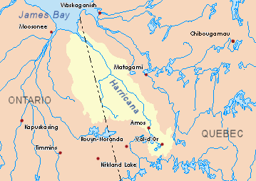
English: Drainage basin of the Harricana River, Quebec and Ontario, Canada. |
| Source | Own work based on info from Atlas of Canada |
| Author | P199 |
Licensing
| I, the copyright holder of this work, release this work into the public domain. This applies worldwide. In some countries this may not be legally possible; if so: I grant anyone the right to use this work for any purpose, without any conditions, unless such conditions are required by law. |
File history
Click on a date/time to view the file as it appeared at that time.
| Date/Time | Thumbnail | Dimensions | User | Comment | |
|---|---|---|---|---|---|
| current | 23:49, 23 November 2008 | | 359 × 254 (19 KB) | P199 | {{Information |Description={{en|1=Drainage basin of the Harricana River, Quebec and Ontario, Canada.}} |Source=Own work based on info from [http://atlas.nrcan.gc.ca/site/english/maps/environment/hydrology/drainagebasins Atlas of Canada] |Author=[[User:P19 |
File usage
The following pages on the English Wikipedia use this file (pages on other projects are not listed):
- Again River
- Boivin River
- Breynat River
- Burntbush River
- Case River
- Chabbie River
- Corner River
- Corset River
- Davoust River
- Despreux River
- Detour River
- East Kabika River
- East Mikwam River
- Enjalran River
- Garneau River
- Harricana River
- Kabika River
- Kadabakato River
- Kenning River
- Lake Turgeon
- Lavergne River
- Little Mikwam River
- Little Turcotte River
- Malouin River
- Mannerelle River
- Martigny River
- Menard River
- Mikwam River
- Mistaouac River
- North Burntbush River
- Novide River
- Ojima River
- Patten River
- Perdrix River (Eeyou Istchee Baie-James)
- South Patten River
- Tangente River
- Théo River
- Trudelle River
- Turcotte River
- Turgeon River (Harricana River tributary)
- Wawagosic River
Global file usage
The following other wikis use this file:
- Usage on arz.wikipedia.org
- Usage on bg.wikipedia.org
- Usage on ceb.wikipedia.org
- Usage on de.wikipedia.org
- Usage on fr.wikipedia.org
- Rivière Harricana
- Rivière Turgeon (rivière Harricana)
- Portail:Abitibi-Témiscamingue/Lumière sur/Archives
- Portail:Abitibi-Témiscamingue/Lumière
- Portail:Abitibi-Témiscamingue/Lumière/16
- Rivière Samson (baie James)
- Rivière Malartic
- Rivière Laine
- Rivière Senneville
- Rivière Milky
- Rivière Bourlamaque
- Rivière Laverdière
- Rivière Fiedmont
- Rivière Vassan
- Rivière Landrienne
- Rivière Peter-Brown
- Rivière Martel
- Rivière Héva
- Lac Lemoine (Val-d'Or)
- Rivière Thompson (lac De Montigny)
- Lac Fournière
- Rivière Fournière
- Rivière Surimau
- Lac Mourier
- Rivière Chicobi
- Lac Chicobi
- Rivière Desboues
- Rivière Berry
- Rivière Davy
- Rivière Octave (rivière Harricana)
- Rivière Miniac
- Rivière Lawagamau
- Rivière Lavergne
- Lac Turgeon (Eeyou Istchee Baie-James)
- Rivière Enjalran
- Rivière Tangente
- Rivière Davoust
- Usage on hy.wikipedia.org
- Usage on it.wikipedia.org
- Usage on no.wikipedia.org
- Usage on pl.wikipedia.org
- Usage on ru.wikipedia.org
- Usage on uk.wikipedia.org
- Usage on www.wikidata.org
View more global usage of this file.