
File:Heiltskuk Icefield, British Columbia.JPG

Size of this preview: 800 × 532 pixels. Other resolutions: 320 × 213 pixels | 640 × 425 pixels | 1,024 × 681 pixels | 1,280 × 851 pixels | 2,560 × 1,702 pixels | 4,256 × 2,829 pixels.
Original file (4,256 × 2,829 pixels, file size: 2.43 MB, MIME type: image/jpeg)
| This is a file from the Wikimedia Commons. Information from its description page there is shown below. Commons is a freely licensed media file repository. You can help. |
Summary
| Description |
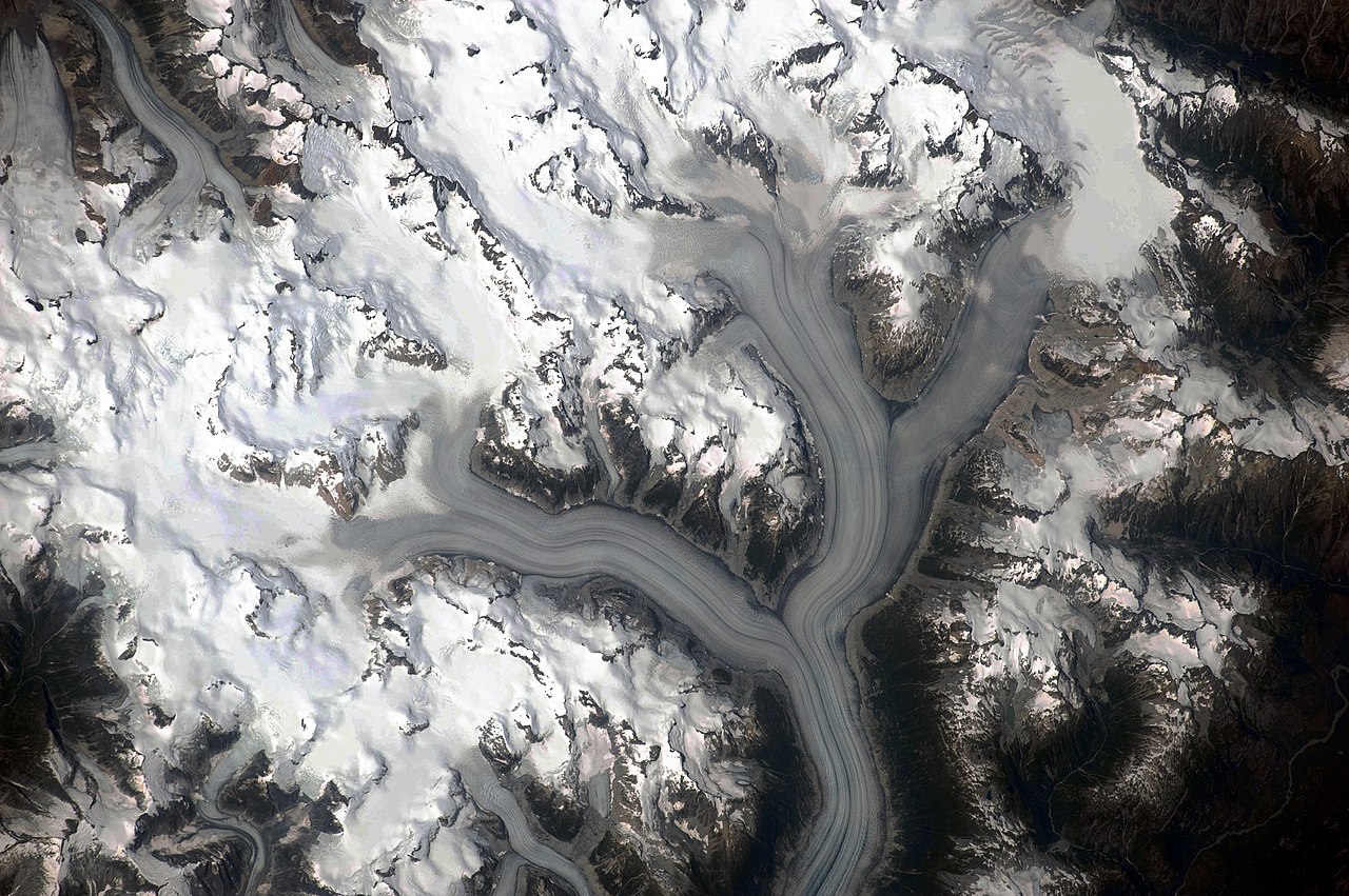
English: This detailed astronaut photograph illustrates the ice-field—mostly covered by snow across the upper mountain slopes—and two major valley glaciers that extend from it. The locations of former valley glaciers can frequently be identified by the presence of these U-shaped valleys on a now glacier-free landscape. The two largest valley glaciers in the image, Silverthrone Glacier and Klinaklini Glacier, both flow towards Knight Inlet to the south (not shown). Several moraines—accumulations of rock and soil debris along the edges and surface of a glacier—are drawn out into long, dark lines by the flowing ice, and they extend along the length of both glaciers. The confluence of the two glaciers at image centre illustrates how a moraine located along the side of a glacier can become a medial moraine, in the centre of the joined ice mass. Smaller valley glaciers are visible near Mount Silverthrone. |
| Date | |
| Source | NASA Earth Observatory |
| Author | NASA Expedition 20 crew |
| Camera location | | View this and other nearby images on: OpenStreetMap |
|---|
This image or video was catalogued by Johnson Space Center of the United States National Aeronautics and Space Administration (NASA) under Photo ID: ISS020-E-29216. This tag does not indicate the copyright status of the attached work. A normal copyright tag is still required. See Commons:Licensing. Other languages:
|
Image acquired with a Nikon D3 digital camera fitted with a 400 mm lens, and is provided by the ISS Crew Earth Observations experiment and Image Science & Analysis Laboratory, Johnson Space Center.
Licensing
| This file is in the public domain in the United States because it was solely created by NASA. NASA copyright policy states that "NASA material is not protected by copyright unless noted". (See Template:PD-USGov, NASA copyright policy page or JPL Image Use Policy.) | ||
 |
Warnings:
|
| Annotations | This image is annotated: View the annotations at Commons |
File history
Click on a date/time to view the file as it appeared at that time.
| Date/Time | Thumbnail | Dimensions | User | Comment | |
|---|---|---|---|---|---|
| current | 11:03, 3 June 2010 | | 4,256 × 2,829 (2.43 MB) | Originalwana | {{Information |Description={{en|1=This detailed astronaut photograph illustrates the ice-field—mostly covered by snow across the upper mountain slopes—and two major valley glaciers that extend from it. The locations of former valley glaciers c |
File usage
The following pages on the English Wikipedia use this file (pages on other projects are not listed):
Global file usage
The following other wikis use this file:
- Usage on ceb.wikipedia.org
- Usage on de.wikipedia.org
- Usage on en.wikiversity.org
- Usage on fr.wikipedia.org
- Usage on www.wikidata.org