
File:Klondike Routes Map.png
Size of this preview: 502 × 599 pixels. Other resolutions: 201 × 240 pixels | 402 × 480 pixels | 644 × 769 pixels.
Original file (644 × 769 pixels, file size: 361 KB, MIME type: image/png)
| This is a file from the Wikimedia Commons. Information from its description page there is shown below. Commons is a freely licensed media file repository. You can help. |
Summary

|
File:Klondike Routes Map.svg is a vector version of this file. It should be used in place of this PNG file when not inferior.
File:Klondike Routes Map.png → File:Klondike Routes Map.svg
For more information, see Help:SVG. |
 |
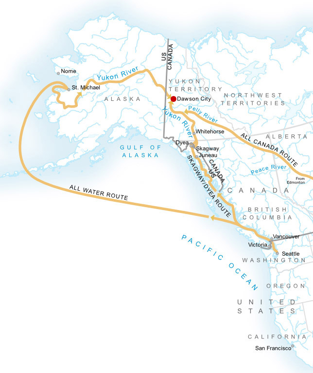
Source: Klondike Routes Map from NPS.
Other versions:

Licensing
| This image or media file contains material based on a work of a National Park Service employee, created as part of that person's official duties. As a work of the U.S. federal government, such work is in the public domain in the United States. See the NPS website and NPS copyright policy for more information. |
File history
Click on a date/time to view the file as it appeared at that time.
| Date/Time | Thumbnail | Dimensions | User | Comment | |
|---|---|---|---|---|---|
| current | 17:46, 14 August 2011 | | 644 × 769 (361 KB) | Soerenfm | Map cropped and Dawson marked |
| 19:17, 21 November 2010 |  | 798 × 846 (313 KB) | Alexrk2 | fix background | |
| 19:11, 21 November 2010 |  | 798 × 846 (409 KB) | Alexrk2 | de:Wikipedia:Kartenwerkstatt#Datei:Klondike_Routes_Map.png | |
| 18:19, 30 August 2006 |  | 523 × 555 (51 KB) | Aconcagua | Klondike Routes Map from NPS. |
File usage
No pages on the English Wikipedia use this file (pages on other projects are not listed).
Global file usage
The following other wikis use this file:
- Usage on ca.wikipedia.org
- Usage on en.wikibooks.org
- Usage on eo.wikipedia.org
- Usage on es.wikipedia.org
- Usage on fi.wikipedia.org
- Usage on fr.wikipedia.org
- Usage on gl.wikipedia.org
- Usage on hi.wikipedia.org
- Usage on id.wikipedia.org
- Usage on it.wikipedia.org
- Usage on ja.wikipedia.org
- Usage on ka.wikipedia.org
- Usage on pl.wikipedia.org
- Usage on ro.wikipedia.org
- Usage on sk.wikipedia.org
- Usage on zh.wikipedia.org