
File:Latitude Longitude Evaporation minus precipitation.jpg

Size of this preview: 800 × 429 pixels. Other resolutions: 320 × 172 pixels | 809 × 434 pixels.
Original file (809 × 434 pixels, file size: 136 KB, MIME type: image/jpeg)
| This is a file from the Wikimedia Commons. Information from its description page there is shown below. Commons is a freely licensed media file repository. You can help. |
Summary
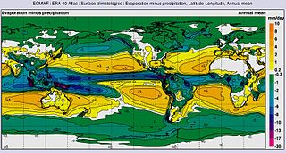
| Description | Global map of Annual mean Evaporation minus precipitation by Latitude-Longitude | |||||
| Date | ||||||
| Source | ERA-40 Atlas [1] [2] | |||||
| Author | NASA & European Centre for Medium-Range Weather Forecasts (ECMWF) | |||||
| Permission (Reusing this file) |
|
Licensing
| This file is in the public domain in the United States because it was solely created by NASA. NASA copyright policy states that "NASA material is not protected by copyright unless noted". (See Template:PD-USGov, NASA copyright policy page or JPL Image Use Policy.) | ||
 |
Warnings:
|
Original upload log
The original description page was here. All following user names refer to en.wikipedia.
| Date/Time | Dimensions | User | Comment |
|---|---|---|---|
| 2014-01-28 17:19:25 | 809× 434× | LollyBear12 | {{Information |Description = Evaporation minus precipitation, Latitude-Longitude, Annual meanThis graph shows how the average surface temperature of the world's oceans has changed since 1880. This graph uses the 1971 to 2000 average as a baseline for... |
File history
Click on a date/time to view the file as it appeared at that time.
| Date/Time | Thumbnail | Dimensions | User | Comment | |
|---|---|---|---|---|---|
| current | 20:18, 5 November 2016 | | 809 × 434 (136 KB) | Zppix | Transferred from en.wikipedia (MTC!) |
File usage
The following pages on the English Wikipedia use this file (pages on other projects are not listed):
Global file usage
The following other wikis use this file:
- Usage on bg.wikipedia.org
- Usage on ca.wikipedia.org
- Usage on cs.wikipedia.org
- Usage on cy.wikipedia.org
- Usage on es.wikipedia.org
- Usage on sr.wikipedia.org
- Usage on tr.wikipedia.org
- Usage on zh.wikipedia.org