
File:2018 United States Senate election in Minnesota results map by county.svg

Size of this PNG preview of this SVG file: 600 × 600 pixels. Other resolutions: 240 × 240 pixels | 480 × 480 pixels | 768 × 768 pixels | 1,024 × 1,024 pixels | 2,048 × 2,048 pixels | 810 × 810 pixels.
Original file (SVG file, nominally 810 × 810 pixels, file size: 46 KB)
| This is a file from the Wikimedia Commons. Information from its description page there is shown below. Commons is a freely licensed media file repository. You can help. |
Summary
| Description |
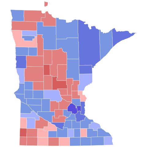
English: County map of US Senate Election in Minnesota, 2018 |
| Date | |
| Source | Own work |
| Author | SpeedMcCool |

Licensing
I, the copyright holder of this work, hereby publish it under the following license:
This file is licensed under the Creative Commons Attribution-Share Alike 4.0 International license.
- You are free:
- to share – to copy, distribute and transmit the work
- to remix – to adapt the work
- Under the following conditions:
- attribution – You must give appropriate credit, provide a link to the license, and indicate if changes were made. You may do so in any reasonable manner, but not in any way that suggests the licensor endorses you or your use.
- share alike – If you remix, transform, or build upon the material, you must distribute your contributions under the same or compatible license as the original.
File history
Click on a date/time to view the file as it appeared at that time.
| Date/Time | Thumbnail | Dimensions | User | Comment | |
|---|---|---|---|---|---|
| current | 00:40, 13 February 2024 | | 810 × 810 (46 KB) | Putitonamap98 | shapes |
| 00:55, 26 May 2021 |  | 744 × 744 (260 KB) | Svenskbygderna | Reverted to version as of 04:44, 15 May 2021 (UTC) | |
| 02:02, 16 May 2021 |  | 289 × 324 (1.08 MB) | TylerKutschbach | Reverted to version as of 23:45, 14 April 2021 (UTC) stop reverting | |
| 04:44, 15 May 2021 |  | 744 × 744 (260 KB) | Elli | no, they don't, these are consistent across states, have more detail, and make more sense to use. | |
| 23:45, 14 April 2021 |  | 289 × 324 (1.08 MB) | TylerKutschbach | Reverted to version as of 17:49, 3 April 2021 (UTC) stop reverting these maps. These maps look much better than the new maps. | |
| 05:30, 14 April 2021 |  | 744 × 744 (260 KB) | Elli | new shapes with working thumbnail | |
| 17:49, 3 April 2021 |  | 289 × 324 (1.08 MB) | TylerKutschbach | Reverted to version as of 15:42, 27 March 2021 (UTC) unnecessary shapes | |
| 18:45, 2 April 2021 |  | 744 × 744 (258 KB) | Awmcphee | Fixed Stevens County | |
| 05:18, 2 April 2021 |  | 744 × 744 (258 KB) | Awmcphee | New shapes. Yes, we intend to replace all of them. I have written a script whose only purpose is reading your past svgs and converting them to the new format. | |
| 15:42, 27 March 2021 |  | 289 × 324 (1.08 MB) | SpeedMcCool | While I appreciate the new shapes, they are inconsistent with the vast majority of MN maps. Unless you plan on updating them all, please use the standard shapes. |
File usage
The following pages on the English Wikipedia use this file (pages on other projects are not listed):
Global file usage
The following other wikis use this file:
- Usage on id.wikipedia.org