
File:MSJAR map.jpg

Size of this preview: 542 × 600 pixels. Other resolutions: 217 × 240 pixels | 434 × 480 pixels | 694 × 768 pixels | 926 × 1,024 pixels | 1,280 × 1,416 pixels.
Original file (1,280 × 1,416 pixels, file size: 157 KB, MIME type: image/jpeg)
| This is a file from the Wikimedia Commons. Information from its description page there is shown below. Commons is a freely licensed media file repository. You can help. |
Summary
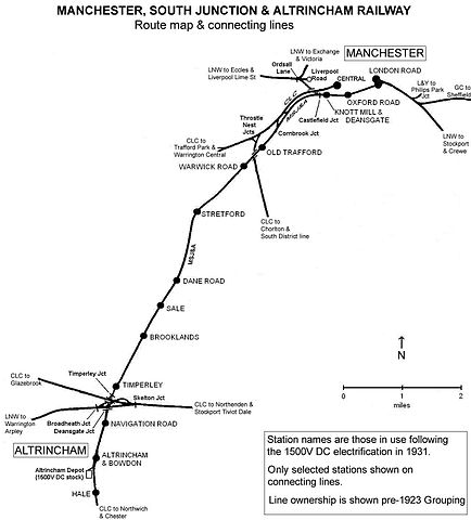
| Description | Route map of the Manchester, South Junction and Altrincham Railway as at December 1931 |
| Date | |
| Source | Own work |
| Author | Ian Threlfall |


Licensing
This file is licensed under the Creative Commons Attribution 2.5 Generic license.
- You are free:
- to share – to copy, distribute and transmit the work
- to remix – to adapt the work
- Under the following conditions:
- attribution – You must give appropriate credit, provide a link to the license, and indicate if changes were made. You may do so in any reasonable manner, but not in any way that suggests the licensor endorses you or your use.
Original upload log
The original description page was here. All following user names refer to en.wikipedia.
| Date/Time | Dimensions | User | Comment |
|---|---|---|---|
| 2006-07-06 12:06:33 | 1280× 1416× | EnglishElectric | Author: Ian Threlfall Subject: Route map of the Manchester, South Junction and Altrincham Railway as at December 1931 |
File history
Click on a date/time to view the file as it appeared at that time.
| Date/Time | Thumbnail | Dimensions | User | Comment | |
|---|---|---|---|---|---|
| current | 10:49, 11 December 2016 | | 1,280 × 1,416 (157 KB) | Jc86035 | Transferred from en.wikipedia (MTC!) |
File usage
The following pages on the English Wikipedia use this file (pages on other projects are not listed):