
File:Marine Mill historical marker.jpg

Original file (1,792 × 2,392 pixels, file size: 1.35 MB, MIME type: image/jpeg)
| This is a file from the Wikimedia Commons. Information from its description page there is shown below. Commons is a freely licensed media file repository. You can help. |
Summary
| Description |
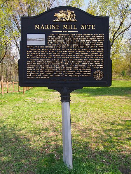
English: Marine Mill historical marker, Marine on St. Croix, Minnesota, USA. TEXT: One of Minnesota's first major industries was born here on August 24, 1839, when the slow, cumbersome up-and-down saw of the Marine Lumber Company cut the first commercial lumber in the state from trees felled in the rich white pine forests of the St. Croix Valley. The mill was built by a group of settlers from Marine, Illinois, at a site selected a year earlier by David Hone and Lewis S. Judd. During the winter of 1839-40, the saw at Marine produced about 5,000 board feet of lumber a day. From this modest beginning, the much rebuilt and enlarged mill of the Walker, Judd and Veazie Lumber Company was by 1877 turning out two million board feet of lumber, 500,000 shingles, and 200,000 laths a year with an average daily work crew of fourteen men. Financial depression, a huge log jam that prevented logs from reaching the mill, extensive tornado damage, and a low-water summer combined to cause the failure of the business in 1885. By 1895, after a few years of intermittent operation in the hands of other companies, the mill closed forever, and the extensive frame buildings were torn down. Only the ruins of the mill's enginehouse, which can be seen by following the path to the overlook, serve as reminder of Minnesota's magnificent pine forests and the profitable lumber industry that built the towns and cities of an expanding nineteenth-century mid-America.
|
||
| Date | |||
| Source | Own work | ||
| Author | McGhiever |
| Camera location | | View this and other nearby images on: OpenStreetMap |
|---|
Licensing
- You are free:
- to share – to copy, distribute and transmit the work
- to remix – to adapt the work
- Under the following conditions:
- attribution – You must give appropriate credit, provide a link to the license, and indicate if changes were made. You may do so in any reasonable manner, but not in any way that suggests the licensor endorses you or your use.
- share alike – If you remix, transform, or build upon the material, you must distribute your contributions under the same or compatible license as the original.
File history
Click on a date/time to view the file as it appeared at that time.
| Date/Time | Thumbnail | Dimensions | User | Comment | |
|---|---|---|---|---|---|
| current | 05:49, 10 December 2015 | | 1,792 × 2,392 (1.35 MB) | McGhiever | User created page with UploadWizard |
File usage
Global file usage
The following other wikis use this file:
- Usage on www.wikidata.org