
File:Montjuïc circuit.svg

Size of this PNG preview of this SVG file: 800 × 531 pixels. Other resolutions: 320 × 212 pixels | 640 × 425 pixels | 1,024 × 680 pixels | 1,280 × 850 pixels | 2,560 × 1,700 pixels | 1,512 × 1,004 pixels.
Original file (SVG file, nominally 1,512 × 1,004 pixels, file size: 318 KB)
| This is a file from the Wikimedia Commons. Information from its description page there is shown below. Commons is a freely licensed media file repository. You can help. |
Summary
| Description |
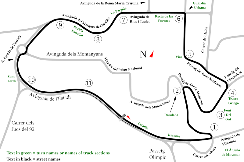
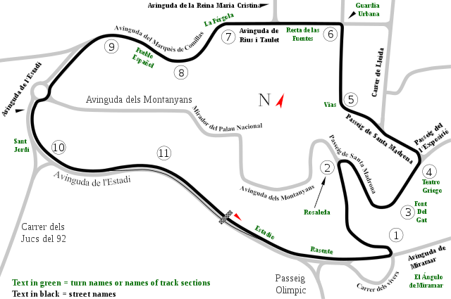
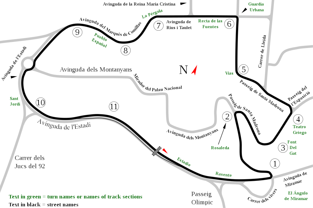
English: Track map of Montjuïc circuit. Gray lines are streets. Green text are either turn names or track section names. Black text (with out the circle) are street names. |
| Date | |
| Source | Own work |
| Author | Will Pittenger |
| Other versions |
|

| Camera location | | View this and other nearby images on: OpenStreetMap |
|---|
Licensing
| I, the copyright holder of this work, release this work into the public domain. This applies worldwide. In some countries this may not be legally possible; if so: I grant anyone the right to use this work for any purpose, without any conditions, unless such conditions are required by law. |
File history
Click on a date/time to view the file as it appeared at that time.
| Date/Time | Thumbnail | Dimensions | User | Comment | |
|---|---|---|---|---|---|
| current | 12:55, 19 July 2008 | | 1,512 × 1,004 (318 KB) | Will Pittenger | Once again, please use the previous version if you need to edit the file. |
| 12:54, 19 July 2008 |  | 1,512 × 1,004 (128 KB) | Will Pittenger | Corrected typos. The text objects that were on paths are back on paths. | |
| 12:20, 19 July 2008 |  | 1,512 × 1,004 (318 KB) | Will Pittenger | Mediawiki/RSVG has problems with text on paths. It tends to hide such text objects. This version gets around that bug by converting such objects to paths. If you need to edit the file, please use the previous version. | |
| 12:17, 19 July 2008 |  | 1,512 × 1,004 (128 KB) | Will Pittenger | New version has keywords added. | |
| 11:58, 19 July 2008 |  | 1,512 × 1,004 (127 KB) | Will Pittenger | This version fixes the document size. | |
| 11:54, 19 July 2008 |  | 744 × 1,052 (126 KB) | Will Pittenger | {{Information |Description={{en|1=Track map of w:Montjuïc circuit. Gray lines are streets. Green text are either turn names or track section names. Black text (with out the circle) are street names.}} |Source=Own work by uploader |Author=[[User:W |
File usage
The following pages on the English Wikipedia use this file (pages on other projects are not listed):
- 1955 Spanish motorcycle Grand Prix
- 1962 Spanish motorcycle Grand Prix
- 1969 Spanish Grand Prix
- 1971 Spanish Grand Prix
- 1973 Spanish Grand Prix
- 1975 Spanish Grand Prix
- 1976 Spanish motorcycle Grand Prix
- List of Formula One circuits
- List of Grand Prix motorcycle circuits
- Montjuïc circuit
- Spanish Grand Prix
- User talk:4u1e/archive5
- User talk:Bam123456789/Archive 1
- User talk:Barkjon/Archive 2
- User talk:Cdhaptomos/Archive 1
- User talk:Chubbennaitor/Archive7
- User talk:Chubbennaitor/archive2
- User talk:Clyde1998/Archive/2008
- User talk:Cs-wolves/Archive 3
- User talk:Donnie Park/Archive 1
- User talk:Hellboy2hell/archive2
- User talk:Midgrid/Archive 6
- User talk:NapHit/Archive 1
- User talk:Readro/Archive 3
- User talk:Sage Callahan/Archive 1
- User talk:Spenalzo/Archive/2008
- User talk:The359/Archive 4
- User talk:Thelb4/Archive 5
- User talk:Typ932/Archive 3
- Wikipedia:WikiProject Formula One/Newsletter/200808
Global file usage
The following other wikis use this file:
- Usage on af.wikipedia.org
- Usage on ar.wikipedia.org
- Usage on ast.wikipedia.org
- Usage on bg.wikipedia.org
- Usage on bn.wikipedia.org
- Usage on br.wikipedia.org
- Usage on ca.wikipedia.org
- Circuit de Montjuïc
- 24 Hores de Montjuïc
- Gran Premi d'Espanya de motociclisme de 1964
- Gran Premi d'Espanya de motociclisme de 1965
- Gran Premi d'Espanya de motociclisme de 1966
- Gran Premi d'Espanya de motociclisme de 1968
- Gran Premi d'Espanya de motociclisme de 1974
- Gran Premi d'Espanya de motociclisme de 1961
- Gran Premi d'Espanya de motociclisme de 1962
- Gran Premi d'Espanya de motociclisme de 1963
- Gran Premi d'Espanya de motociclisme de 1967
- Gran Premi d'Espanya de motociclisme de 1970
- 24 Hores de Montjuïc 1961
- 24 Hores de Montjuïc 1962
- 24 Hores de Montjuïc 1965
- 24 Hores de Montjuïc 1968
- 24 Hores de Montjuïc 1973
- 24 Hores de Montjuïc 1977
- 24 Hores de Montjuïc 1979
- 24 Hores de Montjuïc 1981
- 24 Hores de Montjuïc 1982
- 24 Hores de Montjuïc 1984
- 24 Hores de Montjuïc 1985
- Usage on cs.wikipedia.org
- Usage on de.wikipedia.org
- Usage on eo.wikipedia.org
View more global usage of this file.