
File:National Highway 60 (India).png

Size of this preview: 541 × 599 pixels. Other resolutions: 217 × 240 pixels | 602 × 667 pixels.
Original file (602 × 667 pixels, file size: 239 KB, MIME type: image/png)
| This is a file from the Wikimedia Commons. Information from its description page there is shown below. Commons is a freely licensed media file repository. You can help. |
.png)
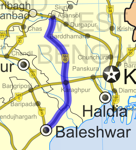
| Description | National Highway 60 in India |
| Date | (UTC) |
| Source | |
| Author |
|
| This is a retouched picture, which means that it has been digitally altered from its original version. The original can be viewed here: India roadway map.svg:
|
I, the copyright holder of this work, hereby publish it under the following license:
This file is licensed under the Creative Commons Attribution-Share Alike 3.0 Unported license.
- You are free:
- to share – to copy, distribute and transmit the work
- to remix – to adapt the work
- Under the following conditions:
- attribution – You must give appropriate credit, provide a link to the license, and indicate if changes were made. You may do so in any reasonable manner, but not in any way that suggests the licensor endorses you or your use.
- share alike – If you remix, transform, or build upon the material, you must distribute your contributions under the same or compatible license as the original.
Original upload log
This image is a derivative work of the following images:
- File:India_roadway_map.svg licensed with Cc-by-sa-3.0
- 2007-04-02T06:14:09Z Gmaxwell 1639x1852 (931168 Bytes) Please do not include copyrighted fonts in your SVGs.
- 2007-04-02T06:13:22Z Gmaxwell 1639x1852 (931168 Bytes) Please do not include copyrighted fonts in your SVGs.
- 2007-01-09T07:33:51Z PlaneMad 1639x1852 (1025350 Bytes) uttaranchal>uttarkhand, minor color corrections and numbering correction
- 2006-11-13T17:04:31Z PlaneMad 1639x1852 (1042154 Bytes) designation for all highways
- 2006-11-09T10:59:17Z PlaneMad 1639x1852 (885509 Bytes) updated karnataka city spellings, added nh 110 112 113 114 116 117 119 121 123 153 154 155 224 225 226 227, corrections in north east states
- 2006-11-06T19:31:09Z PlaneMad 1639x1852 (864712 Bytes) nh designation markers on nhdp highways, rivers enabled, lightened state names, 3d locators for capitals and major cities, minor corrections north east areas
- 2006-10-15T18:01:16Z PlaneMad 1639x1852 (734840 Bytes) Included Nhdp phase IIIA, Changed stroke styles for highways, changed marker locators, added state names, included road legend, added more cities and towns, corrections
- 2006-08-01T18:38:00Z PlaneMad 1639x1852 (619927 Bytes) 100% highway coverage, more towns added, route corrections
- 2006-06-28T18:37:38Z PlaneMad 1639x1852 (1103121 Bytes) added cities and towns throughout india, all rivers added
- 2006-06-27T19:33:15Z PlaneMad 1639x1852 (953120 Bytes) first upload, includes 59000+ km of national highways + NHDP phase I II
Uploaded with derivativeFX
File history
Click on a date/time to view the file as it appeared at that time.
| Date/Time | Thumbnail | Dimensions | User | Comment | |
|---|---|---|---|---|---|
| current | 21:52, 31 May 2009 | | 602 × 667 (239 KB) | Abhijitsathe | {{Information |Description=National Highway 60 in India |Source=*File:India_roadway_map.svg |Date=2009-05-31 22:51 (UTC) |Author=*File:India_roadway_map.svg: '''Cc-by-sa-3.0''' *derivative work: ~~~ |Permission=see below |other_versions= }} { |
File usage
The following pages on the English Wikipedia use this file (pages on other projects are not listed):
Global file usage
The following other wikis use this file:
- Usage on bn.wikipedia.org
- Usage on mr.wikipedia.org
- Usage on www.wikidata.org
.png)