
File:Nilosyrtis Channel.JPG
No higher resolution available.
Nilosyrtis_Channel.JPG (601 × 462 pixels, file size: 55 KB, MIME type: image/jpeg)
| This is a file from the Wikimedia Commons. Information from its description page there is shown below. Commons is a freely licensed media file repository. You can help. |
Summary
| Description |
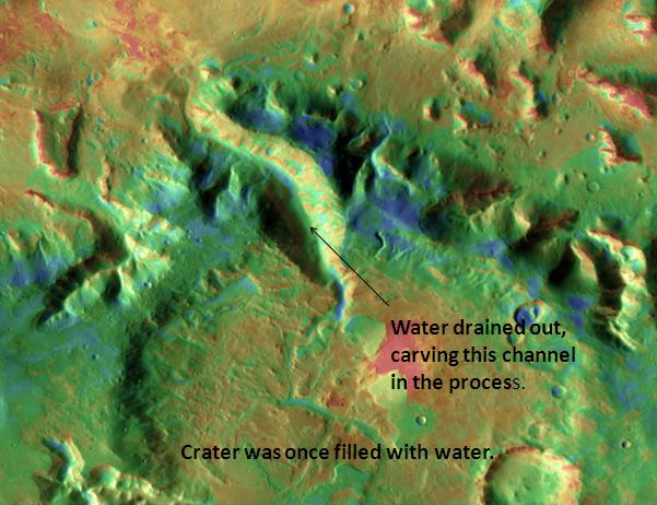
English: Nilosyrtis Channel, as seen by themis. Location is 29.2 degrees north latitude and 73 degrees east longitude. Picture taken with Mars Odyssey's THEMIS. Photo credit NASA/JPL/ASU. |
| Date | |
| Source | http://themis.asu.edu/features/nilosyrtis |
| Author | Jim Secosky modified NASA image. |
Licensing
| This file is in the public domain in the United States because it was solely created by NASA. NASA copyright policy states that "NASA material is not protected by copyright unless noted". (See Template:PD-USGov, NASA copyright policy page or JPL Image Use Policy.) | ||
 |
Warnings:
|
Original upload log
The original description page was here. All following user names refer to en.wikipedia.
| Date/Time | Dimensions | User | Comment |
|---|---|---|---|
| 2009-03-04 19:20 | 601×462× (56265 bytes) | Jimmarsmars | {{Information |Description=Nilosyrtis Channel, as seen by themis. Location is 29.2 degrees north latitude and 73 degrees east longitude. |Source=http://themis.asu.edu/features/nilosyrtis |Date=March 4, 2009 |Author=Jim Secosky modified NASA image. |Permi |
File history
Click on a date/time to view the file as it appeared at that time.
| Date/Time | Thumbnail | Dimensions | User | Comment | |
|---|---|---|---|---|---|
| current | 21:39, 8 December 2014 | | 601 × 462 (55 KB) | Piramidion | Transferred from en.wikipedia |
File usage
The following pages on the English Wikipedia use this file (pages on other projects are not listed):
Global file usage
The following other wikis use this file:
- Usage on es.wikipedia.org
- Usage on uk.wikipedia.org
- Usage on www.wikidata.org