
File:Paraguay - O Prov de Rio de la Plata - cum regionibus adiacentibus Tvcvman et Sta. Cruz de la Sierra - ca 1600.jpg

Size of this preview: 763 × 600 pixels. Other resolutions: 305 × 240 pixels | 611 × 480 pixels | 977 × 768 pixels | 1,280 × 1,006 pixels | 1,661 × 1,306 pixels.
Original file (1,661 × 1,306 pixels, file size: 712 KB, MIME type: image/jpeg)
| This is a file from the Wikimedia Commons. Information from its description page there is shown below. Commons is a freely licensed media file repository. You can help. |
Summary
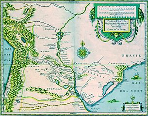
Paraguay, O Prov. de Rio de la Plata: cum regionibus adiacentibus TVCVMAN et Sta. Cruz de la Sierra
(Paraguay, Río de la Plata, Tucumán, Santa Cruz de la Sierra)
Map from around 1600 by Jodocus Hondius (1563-1612)
| Jodocus Hondius I
(1563–1612) |
|||
|---|---|---|---|
 |
|||
| Alternative names |
de Hondt, Josse. Jodocus Hondius the Elder | ||
| Description | Flemish-Dutch cartographer, printmaker, publisher, instrument maker and astronomer | ||
| Date of birth/death |
17 October 1563 |
12 February 1612 | |
| Location of birth/death | Dentergem, Flanders | Amsterdam | |
| Work location | |||
| Authority file | |||
Source: http://www.bvp.org.py/mapas/indice_mapas.htm
Licensing
|
This is a faithful photographic reproduction of a two-dimensional, public domain work of art. The work of art itself is in the public domain for the following reason:
The official position taken by the Wikimedia Foundation is that "faithful reproductions of two-dimensional public domain works of art are public domain".
This photographic reproduction is therefore also considered to be in the public domain in the United States. In other jurisdictions, re-use of this content may be restricted; see Reuse of PD-Art photographs for details. | ||||
File history
Click on a date/time to view the file as it appeared at that time.
| Date/Time | Thumbnail | Dimensions | User | Comment | |
|---|---|---|---|---|---|
| current | 23:12, 23 November 2005 | | 1,661 × 1,306 (712 KB) | ALE! | better colours |
| 22:36, 23 November 2005 |  | 1,661 × 1,306 (758 KB) | ALE! | Paraguay, O Prov. de Rio de la Plata: cum regionibus adiacentibus TVCVMAN et Sta. Cruz de la Sierra (Paraguay, Río de la Plata, Tucuman, Santa Cruz de la Sierra) Map from arround 1600 by Jodocus Hondius (1563-1612) {{Creator:Jodocu |
File usage
The following pages on the English Wikipedia use this file (pages on other projects are not listed):
Global file usage
The following other wikis use this file:
- Usage on ar.wikipedia.org
- Usage on ast.wikipedia.org
- Usage on be.wikipedia.org
- Usage on br.wikipedia.org
- Usage on ca.wikipedia.org
- Usage on cs.wikipedia.org
- Usage on da.wikipedia.org
- Usage on de.wikipedia.org
- Usage on es.wikipedia.org
- Juan de Garay
- Historia de la Argentina
- Jerónimo Luis de Cabrera
- Santa Cruz de la Sierra
- Alonso Mercado y Villacorta
- Provincia de Tucumán
- Domingo Martínez de Irala
- Juan de Ayolas
- Rodrigo Ortiz de Zárate
- Juan de Torres Navarrete
- Pantanal
- Paititi
- Arquidiócesis de Córdoba
- Gobernación del Tucumán
- Gobernación de Nueva Andalucía del Río de la Plata
- Bahía Negra
- Tenencia de gobierno de Santa Fe
- Pedro Carranza
- Cristóbal de Aresti
- Cristóbal de la Mancha y Velazco
- Antonio de Azcona Imberto
- Gabriel de Arregui y Gutiérrez
- Pedro de Fajardo
- Juan de Arregui y Gutiérrez
- Manuel de Frías
- Francés de Beaumont y Navarra
- Mateo Leal de Ayala
- Juan de Lacoizqueta
- Manuel Maciel y Cabral de Alpoin
- Historia económica de Argentina
- Bartolomé González de Villaverde
View more global usage of this file.