
File:Pital nevada.jpg
No higher resolution available.
Pital_nevada.jpg (500 × 350 pixels, file size: 61 KB, MIME type: image/jpeg)
| This is a file from the Wikimedia Commons. Information from its description page there is shown below. Commons is a freely licensed media file repository. You can help. |
Summary
| Description |
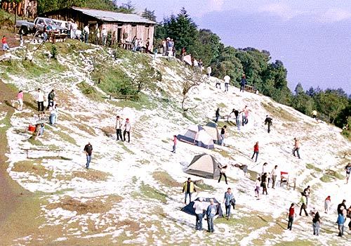
Español: Cerro El Pital se encuentra a 12 kilómetros de La Palma, con una altura de 2730 msnm es el punto más alto del territorio Salvadoreño. Es una montaña en medio de un bosque nebuloso que suele tener una temperatura aproximada de 10 ºC. El 13 de abril de 2004, las temperaturas bajaron tanto que el cerro fue cubierto por una escarcha de hielo que causó conmoción entre los pobladores, atribuyendo el fenómeno a una supuesta "nevada". |
| Date | |
| Source | Own work |
| Author | Wanakoo |
Licensing
I, the copyright holder of this work, hereby publish it under the following license:
This file is licensed under the Creative Commons Attribution-Share Alike 3.0 Unported license.
- You are free:
- to share – to copy, distribute and transmit the work
- to remix – to adapt the work
- Under the following conditions:
- attribution – You must give appropriate credit, provide a link to the license, and indicate if changes were made. You may do so in any reasonable manner, but not in any way that suggests the licensor endorses you or your use.
- share alike – If you remix, transform, or build upon the material, you must distribute your contributions under the same or compatible license as the original.
File history
Click on a date/time to view the file as it appeared at that time.
| Date/Time | Thumbnail | Dimensions | User | Comment | |
|---|---|---|---|---|---|
| current | 06:28, 6 March 2012 | | 500 × 350 (61 KB) | Wanakoo |
File usage
The following pages on the English Wikipedia use this file (pages on other projects are not listed):
Global file usage
The following other wikis use this file:
- Usage on ar.wikipedia.org
- Usage on beta.wikiversity.org
- Usage on en.wikiversity.org
- Usage on es.wikipedia.org
- Usage on ja.wikipedia.org
- Usage on mt.wikipedia.org