
File:Plates tect2 en.svg

Size of this PNG preview of this SVG file: 800 × 546 pixels. Other resolutions: 320 × 218 pixels | 640 × 437 pixels | 1,024 × 699 pixels | 1,280 × 874 pixels | 2,560 × 1,747 pixels | 4,167 × 2,844 pixels.
Original file (SVG file, nominally 4,167 × 2,844 pixels, file size: 247 KB)
| This is a file from the Wikimedia Commons. Information from its description page there is shown below. Commons is a freely licensed media file repository. You can help. |

|
This file requires updating because: the source map was updated by the USGS to correct errors. See this discussion: [1] In doing so, you could add a timestamp to the file.
|
Summary
W3C-validity not checked.
| Description |
[]
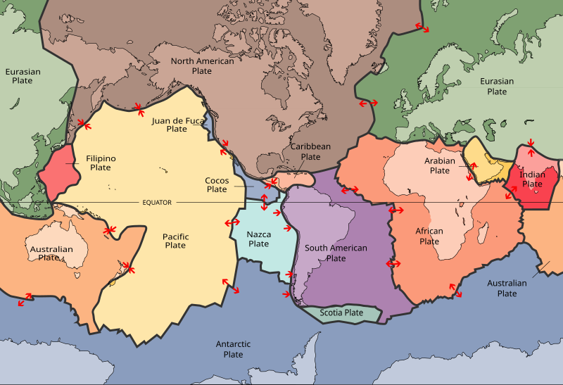
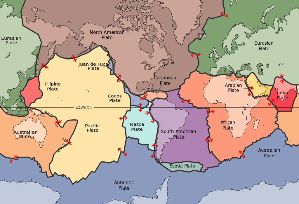
Afrikaans: Die Aarde se tektoniese plate. Bahasa Indonesia: Inti dari tektonika lempeng adalah bahwa litosfer terdiri dari lempeng-lempeng tektonik yang mengambang di atas astenosfer yang serupa fluida (padatan visko-elastik). Fluiditas relatif astenosfer memungkinkan lempeng-lempeng tektonik ini untuk mengalami pergerakan ke arah yang berbeda-beda. Peta ini menunjukkan 15 lempeng terbesar. Perhatikan bahwa Lempeng Indo-Australia bisa terbelah menjadi lempeng India dan Australia (dalam peta ini digambarkan terpisah). Català: Plaques tectòniques Čeština: Mapa tektonických desek Deutsch: Die Lithosphärenplatten der Erde Eesti: Laamade kaart English: The key principle of plate tectonics is that the lithosphere exists as separate and distinct tectonic plates, which float on the fluid-like (visco-elastic solid) asthenosphere. The relative fluidity of the asthenosphere allows the tectonic plates to undergo motion in different directions. This map shows 15 of the largest plates. Note that the Indo-Australian Plate may be breaking apart into the Indian and Australian plates, which are shown separately on this map. Español: Mapa que muestra la ubicación y movimiento de las placas tectónicas en la corteza terrestre Euskara: Plaka tektonikoen banaketa Français : Le principe clé de la tectonique des plaques est que la lithosphère rigide est formée de plaques distinctes et indépendantes, qui flottent sur l'asthénosphère visco-élastique. La fluidité relative de l'asthénosphère permet aux plaques tectoniques de faire des mouvements dans différentes directions. Cette carte montre 15 des plus grandes plaques. Notez que les plaques indienne et australienne, qui sont montrées séparément sur cette carte, soient selon les auteurs parfois regroupées en une seule plaque indo-australienne. Hrvatski: Tektonika ploča Italiano: La struttura e le placche della crosta terrestre. Lëtzebuergesch: Tektonesch Placken Lietuvių: Tektoninės plokštės. Rodyklėmis parodytos judėjimo kryptys Magyar: Tektonikus lemezek Occitan : Mapa de las placas tectonicas mai grandas del mond Srpski (latinica): Zemljine tektonske ploče Sunda: Téktonika lémpéng negeskeun yén litosfér téh diwangun ku sababaraha lémpéng téktonik anu ngambang luhureun asténosfér anu kawas cai (padetan visko-élastik). Ku ayana fluiditas rélatif asténosfér, ieu lémpéng-lémpéng téktonik bisa ojah ka mana waé. Ieu peta némbongkeun 15 lémpéng nu baradag. Imeutan yén Lémpéng Indo-Australia bisa bejad jadi lémpéng India jeung Australia, nu dina ieu peta mémang digambarkeun misah. Suomi: Suomennos maapallon mannerlaatoista ja niiden liikesuunnista. Tiếng Việt: Nguyên tắc quan trọng của kiến tạo mảng là thạch quyển tồn tại dưới dạng các mảng kiến tạo riêng biệt và khác biệt, chúng trôi nổi trên khí quyển giống như chất lỏng (chất rắn đàn hồi). Tính lưu động tương đối của khí quyển cho phép các mảng kiến tạo chuyển động theo các hướng khác nhau. Bản đồ này cho thấy 15 tấm lớn nhất. Lưu ý rằng mảng Ấn-Úc có thể tách ra thành mảng Ấn Độ và Úc, được hiển thị riêng biệt trên bản đồ này. Ελληνικά: Οι τεκτονικές πλάκες Български: Тектонски плочи Македонски: Тектоника на геолошките плочи во светот. Українська: Основним принципом тектоніки плит є те, що літосфера існує як різні і відокремлені тектонічні плити, які плавають в'язкій астеносфері. Відносна рухливість астеносфери дозволяє тектонічним плитам здійснювати рухи в різних напрямках. Ця карта зображує 15 найбільших плит. Зверніть увагу, що Індо-Австралійська плита може бути розділена на Індостанську та Австралійську плити, які показані окремо на цій карті. ไทย: ภาพแสดงการวางตัวของแผ่นเปลือโลก 한국어: 판구조지질학(plate tectonics)의 핵심 원리는 암석권(lithosphere)이 지질구조판들로 따로 존재하면서, 액체같은(점탄성 고체) 연약권(asthenosphere) 위에 떠 있다는 것입니다. 연약권이 상대적으로 액상이어서, 지질구조판들이 다른 방향으로 움직이게 됩니다. 이 지도에 가장 큰 판들 15개를 표시해놓았습니다. 인도-오스트레일리아 판이 인도판과 오스트레일리아판들로 분열되고 있어서, 따로 표시해놓았음을 주목해주시기 바랍니다.(영문 번역) 日本語: 地殻を構成するプレート群 中文: 全球板块图 / 全球板塊圖 العربية : الصفائح التكتونية |
||
| Date | |||
| Source |
This file was derived from:  Tectonic plates.png Tectonic plates.png |
||
| Author |
|
||
| Other versions |
[]
|


![[1]](https://en.wikipedia.org/wiki/File_talk:Plates_tect2_en.svg#Australian_&_Eurasian_Plates_over_Myanmar)
Licensing
This image is in the public domain in the United States because it only contains materials that originally came from the United States Geological Survey, an agency of the United States Department of the Interior. For more information, see the official USGS copyright policy.
|
File history
Click on a date/time to view the file as it appeared at that time.
| Date/Time | Thumbnail | Dimensions | User | Comment | |
|---|---|---|---|---|---|
| current | 11:17, 29 August 2022 | | 4,167 × 2,844 (247 KB) | Vanished User 1930800025 | File uploaded using svgtranslate tool (https://svgtranslate.toolforge.org/). Added translation for tr. |
| 23:42, 5 August 2021 |  | 4,167 × 2,844 (241 KB) | A876 | font-family to use a generic name | |
| 23:24, 5 August 2021 |  | 4,167 × 2,844 (241 KB) | A876 | took text back to characters (previous rev). capitalized "Plate". made most text larger and one-size. | |
| 22:38, 6 November 2011 |  | 4,167 × 2,844 (438 KB) | Hel-hama | text quality improved | |
| 21:08, 14 November 2010 |  | 4,167 × 2,844 (243 KB) | Ras67 | cropped, font fix, Adobe junk removed | |
| 02:06, 20 April 2009 |  | 4,217 × 3,169 (456 KB) | Octane | couple fixes | |
| 21:54, 26 December 2006 |  | 4,217 × 3,169 (450 KB) | AzaToth | if it's small, and it's an svg, lets then resize it :) | |
| 00:42, 26 January 2006 |  | 682 × 462 (450 KB) | Scott Nash | Tectonic plate map with its relative movements. Translated from Image:Placas_tect2_pt_BR.svg. |
File usage
The following pages on the English Wikipedia use this file (pages on other projects are not listed):
- Alfred Wegener
- Continent
- Cosmos: A Spacetime Odyssey
- Crust (geology)
- Earth's crust
- Geography of North America
- Geology
- Homogeneous relation
- List of tsunamis affecting New Zealand
- Lithosphere
- Mid-ocean ridge
- Ring of Fire
- Scientific theory
- Seafloor spreading
- Seven Summits
- Submarine earthquake
- The Lost Worlds of Planet Earth
- West Scotia Basin
- Talk:Earthquake/Archive 2
- Talk:Eurocentrism
- Talk:Geology of North America
- Talk:Indian subcontinent/Archive 1
- Talk:Sicily/Archive 3
- Talk:South Asia/Archive 2
- Talk:Turkey/Archive 20
- User:Big Adamsky
- User:JALockhart
- User:JALockhart/Userboxes/User int Tectonics
- User:Mavisp
- User:Mitternacht90/EarthandSpace
- User:Ndusk
- User:Nightstallion/sandbox
- User:Nurg/Continent
- Wikipedia:Featured picture candidates/January-2007
- Wikipedia:Featured picture candidates/Plate tectonics
- Wikipedia:Reference desk/Archives/Science/2011 December 26
- Wikipedia:Today's featured article/August 12, 2004
- Wikipedia:Today's featured article/August 2004
- Portal:Geography/Featured picture/2007, week 12
- Portal:Geography/Featured picture archive/2007
- Portal:Maps/Maps/World
- Portal:Maps/Maps/World/2
- Portal:Science/Featured article
- Portal:Science/Featured article/19
Global file usage
The following other wikis use this file:
- Usage on anp.wikipedia.org
- Usage on arz.wikipedia.org
- Usage on as.wikipedia.org
- Usage on az.wikipedia.org
- Usage on be-tarask.wikipedia.org
- Usage on beta.wikiversity.org
- Usage on be.wikipedia.org
- Usage on bh.wikipedia.org
- Usage on bn.wikipedia.org
- Usage on ca.wikipedia.org
- Usage on ckb.wikipedia.org
- Usage on cv.wikipedia.org
- Usage on cy.wikipedia.org
- Usage on da.wikipedia.org
- Usage on de.wikipedia.org
- Usage on el.wikipedia.org
- Usage on en.wikibooks.org
- Usage on en.wikiquote.org
- Usage on en.wikiversity.org
- Usage on en.wiktionary.org
- Usage on es.wikipedia.org
- Usage on eu.wikipedia.org
- Usage on fa.wikipedia.org
View more global usage of this file.