
File:REAR (SOUTH) AND EAST ELEVATION (GEN. VIEW) - Arlington Place, 331 Cotton Avenue, Southwest, Birmingham, Jefferson County, AL HABS ALA,37-BIRM,1-5.tif

Size of this JPG preview of this TIF file: 800 × 569 pixels. Other resolutions: 320 × 228 pixels | 640 × 455 pixels | 1,024 × 728 pixels | 1,280 × 911 pixels | 2,560 × 1,821 pixels | 5,000 × 3,557 pixels.
Original file (5,000 × 3,557 pixels, file size: 16.96 MB, MIME type: image/tiff)
| This is a file from the Wikimedia Commons. Information from its description page there is shown below. Commons is a freely licensed media file repository. You can help. |
Summary
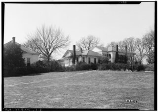
| Historic American Buildings Survey Alex Bush, Photographer, March 4, 1937 REAR (SOUTH) AND EAST ELEVATION (GEN. VIEW) - Arlington Place, 331 Cotton Avenue, Southwest, Birmingham, Jefferson County, AL | ||||
|---|---|---|---|---|
| Title |
Historic American Buildings Survey Alex Bush, Photographer, March 4, 1937 REAR (SOUTH) AND EAST ELEVATION (GEN. VIEW) - Arlington Place, 331 Cotton Avenue, Southwest, Birmingham, Jefferson County, AL |
|||
| Depicted place | Alabama; Jefferson County; Birmingham | |||
| Medium | 5 x 7 in. | |||
| Current location |
Library of Congress Prints and Photographs Division Washington, D.C. 20540 USA http://hdl.loc.gov/loc.pnp/pp.print |
|||
| Accession number |
HABS ALA,37-BIRM,1-5 |
|||
| Credit line |
|
|||
| Source | https://www.loc.gov/pictures/item/al0245.photos.002821p | |||
| Permission (Reusing this file) |
|
|||

| Camera location | | View this and other nearby images on: OpenStreetMap |
|---|
File history
Click on a date/time to view the file as it appeared at that time.
| Date/Time | Thumbnail | Dimensions | User | Comment | |
|---|---|---|---|---|---|
| current | 07:15, 28 June 2014 |  | 5,000 × 3,557 (16.96 MB) | Fæ | GWToolset: Creating mediafile for Fæ. HABS batch upload restart 26 June 2014 (p21:101)x |
File usage
The following pages on the English Wikipedia use this file (pages on other projects are not listed):