
File:Raton-Map.jpg
No higher resolution available.
Raton-Map.jpg (616 × 471 pixels, file size: 33 KB, MIME type: image/jpeg)
| This is a file from the Wikimedia Commons. Information from its description page there is shown below. Commons is a freely licensed media file repository. You can help. |
Summary
| Description |
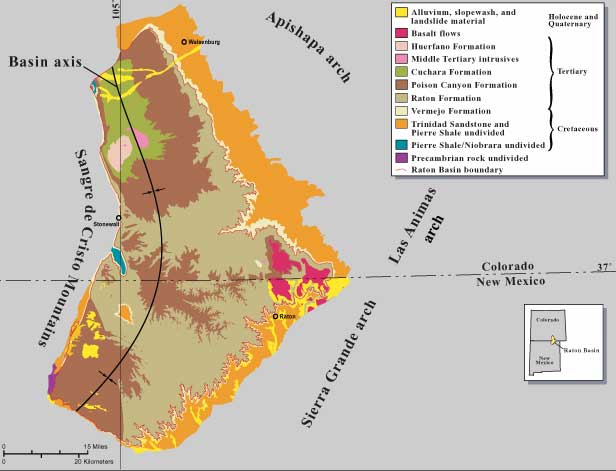
English: Geological map of the Raton Basin, Colorado and New mexico, USA |
| Date | |
| Source | US Geological Survey Bulletin 2184-B, "Potential for a Basin-Centered Gas Accumulation in the Raton Basin, Colorado and New Mexico", p.2. |
| Author | Ronald C. Johnson and Thomas M. Finn |
| Permission (Reusing this file) |
US federal government |
Licensing
This image is in the public domain in the United States because it only contains materials that originally came from the United States Geological Survey, an agency of the United States Department of the Interior. For more information, see the official USGS copyright policy.
|
File history
Click on a date/time to view the file as it appeared at that time.
| Date/Time | Thumbnail | Dimensions | User | Comment | |
|---|---|---|---|---|---|
| current | 02:59, 1 August 2009 | | 616 × 471 (33 KB) | Plazak | {{Information |Description = Geological map of the Raton Basin, Colorado and New mexico, USA |Source = US Geological Survey Bulletin 2184-B, "Potential for a Basin-Centered Gas Accumulation in the Raton Basin, Colorado and New Mexico", p.2. |
File usage
The following pages on the English Wikipedia use this file (pages on other projects are not listed):