
File:Roemischeprovinzentrajan.png

Size of this preview: 800 × 479 pixels. Other resolutions: 320 × 192 pixels | 640 × 384 pixels | 1,218 × 730 pixels.
Original file (1,218 × 730 pixels, file size: 307 KB, MIME type: image/png)
| This is a file from the Wikimedia Commons. Information from its description page there is shown below. Commons is a freely licensed media file repository. You can help. |
Summary
| Description |
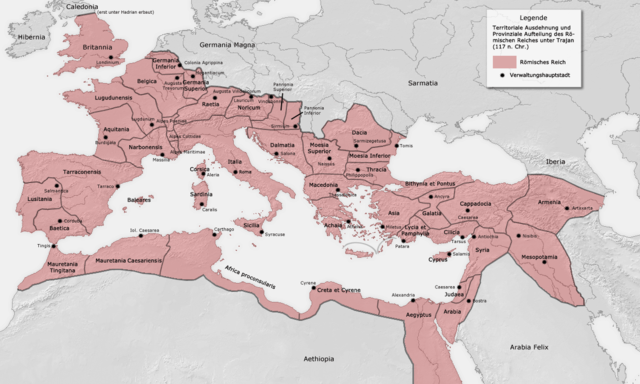
Deutsch: Römische Provinzen (deutsch) English: Roman provinces (German) Español: Provincia romana |
|||
| Date | ||||
| Source | Own work. Karte ist erstellt von mir - Vorlage Demis http://www.demis.nl/wms/mapclip.htm | |||
| Author | FJ-de | |||
| Permission (Reusing this file) |
Public Domain | |||
| Other versions |
|


Licensing
This image is in the public domain because it came from the site https://www.demis.nl/products/web-map-server/examples/ and was released by the copyright holder. Permission is granted to copy, distribute and/or modify this map since it is based on free of copyright images from: www.demis.nl. See also approval email on de.wp and its clarification.
|
| This work has been released into the public domain by its copyright holder, www.demis.nl. This applies worldwide. In some countries this may not be legally possible; if so: www.demis.nl grants anyone the right to use this work for any purpose, without any conditions, unless such conditions are required by law.
|
| This work has been released into the public domain by its author, FJ-de. This applies worldwide. In some countries this may not be legally possible; if so: |
File history
Click on a date/time to view the file as it appeared at that time.
| Date/Time | Thumbnail | Dimensions | User | Comment | |
|---|---|---|---|---|---|
| current | 05:49, 29 June 2007 | | 1,218 × 730 (307 KB) | ThomasPusch | Name of "Mauretania Caesariensis'' (one "s" was missing) corrected - Name von "Mauretania Caesariensis" berichtigt - nomo de "Mauretania Caesariensis'' korektita |
| 11:10, 27 November 2005 |  | 1,218 × 730 (332 KB) | FJ-de | Karte ist erstellt von mir - Vorlage Demis http://www.demis.nl/wms/mapclip.htm |
File usage
The following pages on the English Wikipedia use this file (pages on other projects are not listed):
Global file usage
The following other wikis use this file:
- Usage on af.wikipedia.org
- Usage on als.wikipedia.org
- Usage on ar.wikipedia.org
- Usage on azb.wikipedia.org
- Usage on be.wikipedia.org
- Usage on bg.wikipedia.org
- Usage on br.wikipedia.org
- Usage on ca.wikipedia.org
- Usage on da.wikipedia.org
- Usage on de.wikipedia.org
- Mittelmeer
- Kategorie Diskussion:Staat
- Diskussion:Geschichte Marokkos
- Benutzer:Agibaer
- Benutzer:FJ
- Wikipedia:Löschkandidaten/3. Februar 2007
- Wikipedia:WikiProjekt Kategorien/Diskussionen/2007/Februar/3
- Wikipedia Diskussion:WikiProjekt Geographie/Kategorien/Archiv2
- Wikipedia:Qualitätssicherung/4. Mai 2008
- Benutzer:Uwe Lück/Geografie
- Benutzer:Bene16/Baustelle 11
- Diskussion:Mazedonier (slawischsprachige Ethnie)/Archiv
- Benutzer:Virtualiter/Baustelle2
- Wikipedia:Auskunft/Archiv/2012/Woche 31
- Benutzer:GerhardSchuhmacher/Alpen-Limes
- Benutzer:GerhardSchuhmacher/Zwischenablage
- Usage on eo.wikipedia.org
- Usage on es.wikipedia.org
- Usage on fr.wikipedia.org
View more global usage of this file.