
File:Southern California Indian Linguistic Groups - Juaneño.png

Size of this preview: 800 × 533 pixels. Other resolutions: 320 × 213 pixels | 640 × 426 pixels | 1,024 × 682 pixels | 1,280 × 852 pixels | 2,151 × 1,432 pixels.
Original file (2,151 × 1,432 pixels, file size: 752 KB, MIME type: image/png)
| This is a file from the Wikimedia Commons. Information from its description page there is shown below. Commons is a freely licensed media file repository. You can help. |
Summary
| Description |
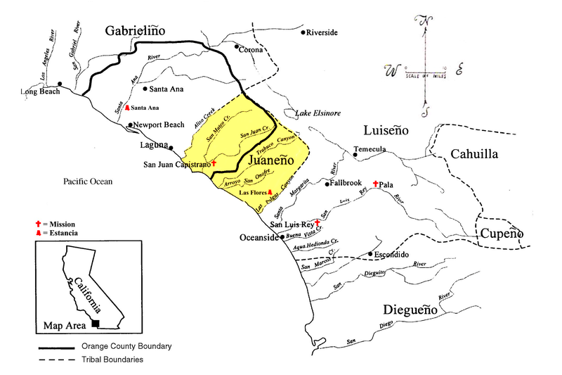
English: Map showing territory boundaries based on Native American linguistic groups in Southern California. |
| Date | |
| Source | Own work by the original uploader |
| Author | Mdhennessey |

Licensing
I, the copyright holder of this work, hereby publish it under the following licenses:

|
Permission is granted to copy, distribute and/or modify this document under the terms of the GNU Free Documentation License, Version 1.2 or any later version published by the Free Software Foundation; with no Invariant Sections, no Front-Cover Texts, and no Back-Cover Texts. A copy of the license is included in the section entitled GNU Free Documentation License. |
| This file is licensed under the Creative Commons Attribution-Share Alike 3.0 Unported license. | ||
| ||
| This licensing tag was added to this file as part of the GFDL licensing update. |
This file is licensed under the Creative Commons Attribution 2.5 Generic license.
- You are free:
- to share – to copy, distribute and transmit the work
- to remix – to adapt the work
- Under the following conditions:
- attribution – You must give appropriate credit, provide a link to the license, and indicate if changes were made. You may do so in any reasonable manner, but not in any way that suggests the licensor endorses you or your use.
You may select the license of your choice.
Original upload log
The original description page was here. All following user names refer to en.wikipedia.
- 2007-08-16 23:09 Mdhennessey 2151×1432× (769723 bytes) Map showing territory boundaries based on Native American linguistic groups in Southern California. Image prepared by me utilizing a PD (public domain) image as a basis.
File history
Click on a date/time to view the file as it appeared at that time.
| Date/Time | Thumbnail | Dimensions | User | Comment | |
|---|---|---|---|---|---|
| current | 12:56, 31 May 2019 | | 2,151 × 1,432 (752 KB) | OgreBot | (BOT): Uploading old version of file from en.wikipedia; originally uploaded on 2007-08-16 23:09:54 by Mdhennessey |
| 01:24, 28 May 2019 |  | 1,600 × 1,065 (583 KB) | Noahedits | User created page with UploadWizard |
File usage
The following pages on the English Wikipedia use this file (pages on other projects are not listed):
Global file usage
The following other wikis use this file:
- Usage on pt.wikipedia.org