
File:St.Edith's churchyard, Little Carlton, Lincs. - geograph.org.uk - 108077.jpg
No higher resolution available.
St.Edith's_churchyard,_Little_Carlton,_Lincs._-_geograph.org.uk_-_108077.jpg (640 × 427 pixels, file size: 99 KB, MIME type: image/jpeg)
| This is a file from the Wikimedia Commons. Information from its description page there is shown below. Commons is a freely licensed media file repository. You can help. |
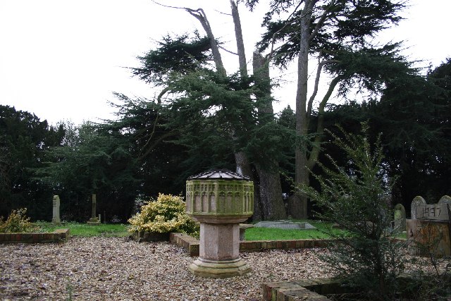
This is a photo of listed building number 1308787. |
Summary
| Description |
English: St Edith's parish churchyard, Little Carlton, Lincolnshire. The octagonal Perpendicular Gothic baptismal font and ground plan in brick edging are all that remains of the former church. A church built of chalk in Little Carlton was recorded in the Domesday Book of 1086. The church was rebuilt in 1837 using the original materials. The last service and baptism were held in October 1978 and the last carol service in December 1978. The church was declared redundant in 1981 and demolished in 1993. |
| Date | |
| Source | From geograph.org.uk |
| Author | Richard Croft |
| Attribution (required by the license) | Richard Croft / St.Edith's churchyard, Little Carlton, Lincs. / |
| Object location | | View this and other nearby images on: OpenStreetMap |
|---|
_&language=en)
Licensing

|
This image was taken from the Geograph project collection. See this photograph's page on the Geograph website for the photographer's contact details. The copyright on this image is owned by Richard Croft and is licensed for reuse under the Creative Commons Attribution-ShareAlike 2.0 license.
|
This file is licensed under the Creative Commons Attribution-Share Alike 2.0 Generic license.
Attribution: Richard Croft
- You are free:
- to share – to copy, distribute and transmit the work
- to remix – to adapt the work
- Under the following conditions:
- attribution – You must give appropriate credit, provide a link to the license, and indicate if changes were made. You may do so in any reasonable manner, but not in any way that suggests the licensor endorses you or your use.
- share alike – If you remix, transform, or build upon the material, you must distribute your contributions under the same or compatible license as the original.
File history
Click on a date/time to view the file as it appeared at that time.
| Date/Time | Thumbnail | Dimensions | User | Comment | |
|---|---|---|---|---|---|
| current | 01:49, 31 January 2010 | | 640 × 427 (99 KB) | GeographBot | == {{int:filedesc}} == {{Information |description={{en|1=St.Edith's churchyard, Little Carlton, Lincs. The octagonal Perpendicular font and ground plan in brick edging is all that remains of St.Edith's church at South Carlton. A church built of chalk in L |
File usage
The following pages on the English Wikipedia use this file (pages on other projects are not listed):
Global file usage
The following other wikis use this file:
- Usage on ceb.wikipedia.org
- Usage on cy.wikipedia.org
- Usage on fr.wikipedia.org
- Usage on lld.wikipedia.org
- Usage on www.wikidata.org