
File:Thermopylae map 480bc.png
No higher resolution available.
Thermopylae_map_480bc.png (542 × 417 pixels, file size: 24 KB, MIME type: image/png)
| This is a file from the Wikimedia Commons. Information from its description page there is shown below. Commons is a freely licensed media file repository. You can help. |
Summary
| Description |
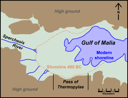
English: Map of Thermopylae area with modern shoreline and reconstructed shoreline of 480 BC. Loosely based on figure 3.19 in Geoarchaeology: The Earth-science Approach to Archaeological Interpretation, p. 96. George Robert Rapp, Christopher L. Hill. Yale University Press, 2006. ISBN 0300109660 |
| Date | |
| Source | Own work |
| Author | ChrisO |
| Permission (Reusing this file) |
Public domain |
| Other versions | Derivative works of this file: Thermopylae map 480bc-es.svg |
Licensing
| I, the copyright holder of this work, release this work into the public domain. This applies worldwide. In some countries this may not be legally possible; if so: I grant anyone the right to use this work for any purpose, without any conditions, unless such conditions are required by law. |
File history
Click on a date/time to view the file as it appeared at that time.
| Date/Time | Thumbnail | Dimensions | User | Comment | |
|---|---|---|---|---|---|
| current | 23:59, 30 September 2008 | | 542 × 417 (24 KB) | ChrisO | {{Information |Description={{en|1=Map of Thermopylae area with modern shoreline and reconstructed shoreline of 480 BC. Loosely based on figure 3.19 in ''Geoarchaeology: The Earth-science Approach to Archaeological Interpretation'', p. 96. George Robert Ra |
File usage
No pages on the English Wikipedia use this file (pages on other projects are not listed).
Global file usage
The following other wikis use this file:
- Usage on azb.wikipedia.org
- Usage on fi.wikipedia.org
- Usage on fr.wikipedia.org
- Usage on ko.wikipedia.org
- Usage on mk.wikipedia.org
- Usage on tr.wikipedia.org
- Usage on uz.wikipedia.org