
File:Utrecht position.svg

Size of this PNG preview of this SVG file: 200 × 236 pixels. Other resolutions: 203 × 240 pixels | 407 × 480 pixels | 651 × 768 pixels | 868 × 1,024 pixels | 1,736 × 2,048 pixels.
Original file (SVG file, nominally 200 × 236 pixels, file size: 157 KB)
| This is a file from the Wikimedia Commons. Information from its description page there is shown below. Commons is a freely licensed media file repository. You can help. |
Summary
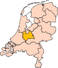
| Description | Location of the province of Utrecht in the Netherlands. |
| Date | |
| Source | Own work, based on freely available GIS data |
| Author | User:Mtcv |
| Permission (Reusing this file) |
Data: attribution required; my work: PD |
| Other versions | I attempted to make an svg version of Image:Utrecht-Position.png (with less simplified boundaries) |
Clickable version

Licensing

|
The copyright holder of this file, Centraal Bureau voor de Statistiek, allows anyone to use it for any purpose, provided that the copyright holder is properly attributed. Redistribution, derivative work, commercial use, and all other use is permitted. |
Attribution:
|
| Annotations | This image is annotated: View the annotations at Commons |


File history
Click on a date/time to view the file as it appeared at that time.
| Date/Time | Thumbnail | Dimensions | User | Comment | |
|---|---|---|---|---|---|
| current | 17:20, 2 March 2019 | | 200 × 236 (157 KB) | Thayts | update |
| 00:49, 3 October 2006 |  | 200 × 236 (158 KB) | Mtcv | {{Information| |Description=Location of the province of Noord-Holland (North Holland) in the Netherlands. |Source=Own work, based on freely available GIS data |Date=2006-10-03 |Author=User:Mtcv |Permission=Data: attribution required; my work: PD |othe |
File usage
The following pages on the English Wikipedia use this file (pages on other projects are not listed):
- Amersfoort
- Baarn
- Bunnik
- Bunschoten
- De Bilt
- De Ronde Venen
- Eemnes
- Grebbeberg
- Houten
- IJsselstein
- Leusden
- Lopik
- Montfoort
- Nieuwegein
- Oudewater
- Renswoude
- Rhenen
- Soest, Netherlands
- Stichtse Vecht
- Utrecht
- Utrecht (province)
- Utrechtse Heuvelrug
- Veenendaal
- Vijfheerenlanden
- Wijk bij Duurstede
- Woerden
- Woudenberg
- Zeist (municipality)
- Wikipedia:WikiProject Netherlands/Dutch municipalities task force/Templates
- Template:Utrecht Province
Global file usage
The following other wikis use this file:
- Usage on ar.wikipedia.org
- Usage on be-tarask.wikipedia.org
- Usage on be.wikipedia.org
- Usage on cy.wikipedia.org
- Usage on en.wiktionary.org
- Usage on eu.wikipedia.org
- Usage on fi.wikipedia.org
- Usage on fr.wiktionary.org
- Usage on hu.wikipedia.org
- Usage on id.wikipedia.org
- Usage on incubator.wikimedia.org
- Usage on lb.wikipedia.org
- Usage on nds-nl.wikipedia.org
View more global usage of this file.