
File:West Point Fortifications.jpg
No higher resolution available.
West_Point_Fortifications.jpg (455 × 420 pixels, file size: 161 KB, MIME type: image/jpeg)
| This is a file from the Wikimedia Commons. Information from its description page there is shown below. Commons is a freely licensed media file repository. You can help. |
Summary
| Description |
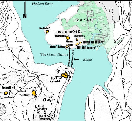
English: Map of West Point fortifications during the Revolutionary War from 1775-1783 |
| Date | |
| Source | United States Military Academy Department of Geography |
| Author | United States Military Academy Department of Geography |
| Permission (Reusing this file) |
Government Source |
Licensing
This file is a work of a U.S. Army soldier or employee, taken or made as part of that person's official duties. As a work of the U.S. federal government, it is in the public domain in the United States.
|
 |
File history
Click on a date/time to view the file as it appeared at that time.
| Date/Time | Thumbnail | Dimensions | User | Comment | |
|---|---|---|---|---|---|
| current | 19:14, 19 April 2008 | | 455 × 420 (161 KB) | Timt1006 | {{Information |Description= Map of West Point fortifications during the Revolutionary War |Source= United States Military Academy Department of Geography |Date= 19 APRIL 2008 |Author= United States Military Academy Department of Geography |Permission= Gov |
File usage
The following pages on the English Wikipedia use this file (pages on other projects are not listed):
Global file usage
The following other wikis use this file:
- Usage on hy.wikipedia.org