
File:World population density map.PNG

Size of this preview: 800 × 352 pixels. Other resolutions: 320 × 141 pixels | 640 × 282 pixels | 1,427 × 628 pixels.
Original file (1,427 × 628 pixels, file size: 34 KB, MIME type: image/png)
| This is a file from the Wikimedia Commons. Information from its description page there is shown below. Commons is a freely licensed media file repository. You can help. |
Summary
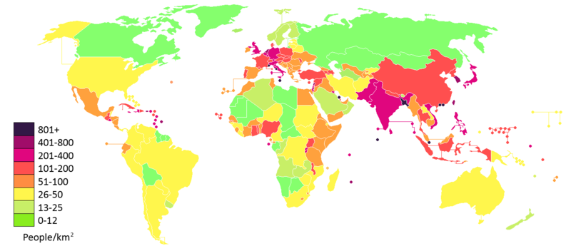
Countries of the world by population density, based on August 2014 version of wikipedia:List of countries by population density. Figures in people per km².

|
File:Countries by population density.svg is a vector version of this file. It should be used in place of this PNG file.
File:World population density map.PNG → File:Countries by population density.svg
For more information, see Help:SVG. |
 |
Countries of the world by population density, based on 30 March 2006 version of wikipedia:List of countries by population density. Figures in people per km²
Licensing

|
Permission is granted to copy, distribute and/or modify this document under the terms of the GNU Free Documentation License, Version 1.2 or any later version published by the Free Software Foundation; with no Invariant Sections, no Front-Cover Texts, and no Back-Cover Texts. A copy of the license is included in the section entitled GNU Free Documentation License. |
| This file is licensed under the Creative Commons Attribution-Share Alike 3.0 Unported license. | ||
| ||
| This licensing tag was added to this file as part of the GFDL licensing update. |
File history
Click on a date/time to view the file as it appeared at that time.
| Date/Time | Thumbnail | Dimensions | User | Comment | |
|---|---|---|---|---|---|
| current | 14:07, 27 March 2018 | | 1,427 × 628 (34 KB) | Zax | Reverted to version as of 19:30, 31 March 2017 (UTC) |
| 14:00, 23 March 2018 |  | 628 × 1,427 (26 KB) | SteinsplitterBot | Bot: Image rotated by 90° | |
| 19:30, 31 March 2017 |  | 1,427 × 628 (34 KB) | MrLeopold | Updated the map once more. | |
| 19:26, 31 March 2017 |  | 1,427 × 628 (34 KB) | MrLeopold | Updated the map. | |
| 19:26, 31 March 2017 |  | 1,427 × 628 (52 KB) | MrLeopold | Reverted to version as of 14:58, 27 August 2015 (UTC) | |
| 19:24, 31 March 2017 |  | 1,427 × 628 (34 KB) | MrLeopold | Updated the map. | |
| 14:58, 27 August 2015 |  | 1,427 × 628 (52 KB) | Sunil060902 | Corrected Lakshadweep (part of India, not Maldives). Now pink, not black. | |
| 18:27, 21 June 2015 |  | 1,427 × 628 (34 KB) | GregKaye | Re working entire map from different base so as to permit use of "paint bucket" facility when editing. Change to a closer approx of logarithmic scales. Changing colours as per talk page suggestions for better differentiation between colours but keepi... | |
| 04:13, 9 October 2014 |  | 2,628 × 1,196 (105 KB) | Leftcry | Canada | |
| 16:21, 1 August 2014 |  | 2,628 × 1,196 (105 KB) | Kohelet | New data and better map |
File usage
The following pages on the English Wikipedia use this file (pages on other projects are not listed):
Global file usage
The following other wikis use this file:
- Usage on ar.wikipedia.org
- Usage on arz.wikipedia.org
- Usage on bn.wikipedia.org
- Usage on ckb.wikipedia.org
- Usage on cy.wikipedia.org
- Usage on da.wikipedia.org
- Usage on da.wikibooks.org
- Usage on de.wikipedia.org
- Usage on en.wikiversity.org
- Usage on en.wiktionary.org
- Usage on et.wikipedia.org
- Usage on eu.wikipedia.org
- Usage on fiu-vro.wikipedia.org
- Usage on fi.wikipedia.org
- Usage on fi.wiktionary.org
- Usage on fo.wikipedia.org
- Usage on fr.wikipedia.org
- Usage on fr.wiktionary.org
- Usage on fy.wikipedia.org
- Usage on ga.wikipedia.org
- Usage on gl.wikipedia.org
- Usage on he.wikipedia.org
- Usage on hi.wikipedia.org
- Usage on hr.wikipedia.org
- Usage on hu.wikipedia.org
- Usage on ia.wikipedia.org
- Usage on ig.wikipedia.org
- Usage on ilo.wikipedia.org
- Usage on incubator.wikimedia.org
- Usage on it.wikipedia.org
- Usage on it.wikiquote.org
- Usage on ja.wikipedia.org
- Usage on kk.wikipedia.org
- Usage on km.wikipedia.org
- Usage on ko.wikipedia.org
- Usage on ku.wikipedia.org
- Usage on lij.wikipedia.org
View more global usage of this file.